NoMa–Gallaudet U station
| Washington Metro rapid transit station | |||||||||||
 |
|||||||||||
| Location | 200 Florida Avenue, NE Washington, DC 20002 |
||||||||||
| Coordinates | 38°54′24″N 77°00′12″W / 38.906596°N 77.003357°WCoordinates: 38°54′24″N 77°00′12″W / 38.906596°N 77.003357°W | ||||||||||
| Owned by | WMATA | ||||||||||
| Line(s) | |||||||||||
| Platforms | 1 island platform | ||||||||||
| Tracks | 2 | ||||||||||
| Connections |
|
||||||||||
| Construction | |||||||||||
| Structure type | at-grade | ||||||||||
| Bicycle facilities | 8 racks | ||||||||||
| Disabled access | Yes | ||||||||||
| Other information | |||||||||||
| Station code | B3.5 or B35 | ||||||||||
| History | |||||||||||
| Opened | November 20, 2004 | ||||||||||
| Previous names | New York Ave (planning & construction) New York Ave–Florida Ave–Gallaudet U (2004–2011) |
||||||||||
| Traffic | |||||||||||
| Passengers (2016) | 8,603 daily |
||||||||||
| Services | |||||||||||
|
|||||||||||
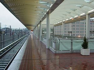
NoMa–Gallaudet U is an elevated, island platformed station on the Washington Metropolitan Area Transit Authority's (WMATA) Metro system. It serves the Red Line, and is situated between Union Station and Rhode Island Avenue–Brentwood stations. NoMa–Gallaudet U is located near the intersection of New York Avenue and Florida Avenue in Northeast Washington, D.C.. The station is within the NoMa neighborhood, which is both residential and commercial, and the station itself is in a commercial district on Florida Avenue. The station opened under the name New York Ave–Florida Ave–Gallaudet U on November 20, 2004, as both the system's first infill station and as the first to be built with a mix of public and private funds.
The station was not originally built with the rest of the Red Line; the segment of the Red Line containing the site of this station opened in 1976. By 1996, however, the idea of a Metro station at New York Avenue was being proposed as part of greater improvements of New York Avenue between Downtown Washington at the Maryland state line. In February 1999, the major property owners in the vicinity of the proposed station agreed in principle to contribute approximately $25 million in private financing for the project. The money would be collected from all commercial property owners within .5-mile (0.80 km) radius of the proposed station by being charged special tax assessments. With an estimated cost of $84 million to complete in October 2000, the federal government approved $25 million for its construction. The remaining costs would be split with $34 million coming from the District and $25 million coming from special tax assessments for the surrounding commercial properties. With funding secured, physical construction could commence.
...
Wikipedia
