Florida Avenue (Washington, D.C.)

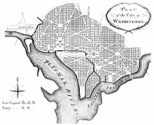
The 1791 L'Enfant plan, under which Boundary Street (now Florida Avenue) marked the northern limits of the City of Washington from Rock Creek in the west to 15th Street in the northeast
|
|
| Other name(s) | Florida Avenue NW Florida Avenue NE |
|---|---|
| Former name(s) | Boundary Street |
| Maintained by | DDOT |
| Location | Washington, D.C., U.S. |
| Coordinates | 38°54′59.6″N 77°1′21.2″W / 38.916556°N 77.022556°WCoordinates: 38°54′59.6″N 77°1′21.2″W / 38.916556°N 77.022556°W |
| West end | Massachusetts Avenue |
| Major junctions |
Connecticut Avenue U / 18th Streets 16th Street North Capitol Street |
| East end | Starburst Plaza |
| Construction | |
| Commissioned | 1791 |
| Completion | 1818 |
Florida Avenue is a major street in Washington, D.C. It was originally named Boundary Street, because it formed the northern boundary of the Federal City under the 1791 L'Enfant Plan. With the growth of the city beyond its original borders, Boundary Street was renamed Florida Avenue in 1890.
On July 9, 1790, Congress passed the Residence Act, which approved the creation of a national capital on the Potomac River. The exact location was to be selected by President George Washington, who chose a portion of the states of Maryland and Virginia on January 24, 1791. Originally, government officials did not foresee that the city of Washington would expand to fill the boundaries of the entire District of Columbia. The "Federal City", or City of Washington, originally lay within an area bounded by Boundary Street (northwest and northeast), 15th Street Northeast, East Capitol Street, the Anacostia River, the Potomac River, and Rock Creek.
The first section of Boundary Street to be opened was between North Capitol Street and 2nd Street NE in 1818. By 1828, the street extended westward at least to 19th Street NW. Boundary Street was graded in late 1869 and early 1870, which dropped the street some 7 to 8 feet (2.1 to 2.4 m) in places.
Boundary Street was renamed Florida Avenue in 1890.
The western terminus of Florida Avenue is at Massachusetts Avenue NW, 22nd Street NW, and Q Street NW. From that terminus to 9th Street NW, Florida Avenue follows a winding path due to the city's topography. From 9th Street NW, Florida Avenue follows a straight line to its eastern terminus at the "Starburst intersection" of H Street NE, 15th Street NE, Maryland Avenue NE, Benning Road NE, and Bladensburg Road NE.
Florida Avenue passes along the foot of the hilly terrain of Northwest Washington, D.C. This hilly area is the Wicomico-Sunderland Escarpment, which is part of the Atlantic Seaboard fall line. The escarpment help marks the transition between the Appalachian Piedmont region north of the avenue and the flat Atlantic Coastal Plain terrain of the city's downtown area to the south.
...
Wikipedia
