Massachusetts Avenue (Washington, DC)

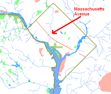
Route map of Massachusetts Avenue
|
|
| Other name(s) | Massachusetts Avenue SE Massachusetts Avenue NE Massachusetts Avenue NW |
|---|---|
| Maintained by | DDOT |
| Width | 160 feet (49 m) |
| Location | Washington, D.C., U.S. |
| Coordinates | 38°54′50″N 77°3′6″W / 38.91389°N 77.05167°W |
| West end | Southern Avenue |
| Major junctions |
Randle Circle Lincoln Park Stanton Park Columbus Circle North Capitol Street Mount Vernon Square Thomas Circle Scott Circle Dupont Circle Sheridan Circle Rock Creek & Potomac Parkway Wisconsin Avenue Ward Circle |
| East end | Westmoreland Circle |
| Construction | |
| Completion | 1871 |
|
Massachusetts Avenue Historic District
|
|

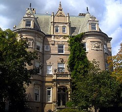
The Miller House, a contributing property to the Massachusetts Avenue Historic District
|
|
| Location | Both sides of Massachusetts Avenue between 17th Street and Observatory Circle, NW |
|---|---|
| Coordinates | 38°54′50″N 77°3′6″W / 38.91389°N 77.05167°WCoordinates: 38°54′50″N 77°3′6″W / 38.91389°N 77.05167°W |
| Area | 81 acres (33 ha) |
| Built | 1871 |
| Architect | Multiple |
| Architectural style | Late Victorian, Beaux Arts |
| NRHP Reference # | 74002166 |
| Added to NRHP | October 22, 1974 |
Massachusetts Avenue is a major diagonal transverse road in Washington, D.C., and the Massachusetts Avenue Historic District is a historic district that includes part of it.
Appearing in Peter Charles L'Enfant's original plan, Massachusetts Avenue crosses three of Washington's four quadrants. It intersects every major north–south street and passes numerous Washington landmarks. It is a landmark itself, long considered the northern boundary of the downtown as well as home of Washington's Embassy Row.
Massachusetts Avenue is tied with Pennsylvania Avenue as the widest road in the District, at 160 feet (49 m). The two roads run in parallel through much of the city, Massachusetts about seven blocks north of Pennsylvania. Massachusetts Avenue was long Washington's premier residential street, as Pennsylvania was once its most sought-after business address. Both streets were named after states with prominent roles in the American Revolution.
The historic district is an 81-acre (33 ha) area that includes 150 contributing buildings and 3 contributing structures. It was listed on the National Register of Historic Places in 1985. It includes multiple properties that are individually listed on the National Register.
The main section of Massachusetts Avenue begins at 19th Street Southeast, just to the west of the former District of Columbia General Hospital site and one block north of Congressional Cemetery. At elevation with respect to the hospital, Massachusetts Avenue commands a view of the Anacostia River. It proceeds in a northwesterly direction crosstown. At Lincoln Park the road enters Northeast D.C. and the neighborhood of Capitol Hill. After briefly converging with Columbus Circle as it curves around Union Station, Massachusetts enters Northwest D.C. in a rapidly changing neighborhood which has transitioned from earlier blight and decay to in the 21st century developing numerous high-rise apartment complexes. In the tradition of the acronym SoHo, realtors sometimes give this area the moniker NoMa (North of Massachusetts Avenue).
...
Wikipedia

