Nizhnyaya Tunguska River
| Nizhnyaya Tunguska (Нижняя Тунгуска) | |
| River | |
|
The Lower Tunguska crosses the Putorana Plateau.
|
|
| Tributaries | |
| - right | Kochechum |
| Cities | Turukhansk, Tura, Erbogachen |
|---|---|
| Source | |
| - location | Central Siberian Plateau, Russia |
| Mouth | Yenisei river |
| Length | 2,989 km (1,857 mi) |
| Basin | 473,000 km2 (182,626 sq mi) |
| Discharge | for Yenisei river |
| - average | 3,680 m3/s (129,958 cu ft/s) |
| - max | 112,000 m3/s (3,955,243 cu ft/s) |
| - min | 1 m3/s (35 cu ft/s) |
|
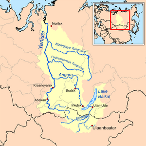
Map of the Yenisei basin that shows the Nizhnyaya Tunguska river
|
|
Coordinates: 65°47′00″N 87°57′20″E / 65.78333°N 87.95556°E
Nizhnyaya Tunguska (Russian: Ни́жняя Тунгу́ска; IPA: [ˈnʲiʐnʲɪjə tʊnˈɡuskə], meaning Lower Tunguska) is a river in Siberia, Russia, that flows through the Irkutsk Oblast and the Krasnoyarsk Krai. The river is a tributary of the Yenisei joining it at Turukhansk (see Siberian River Routes). Settlements on the river include Tura, Yukti and Simenga. The ice-free period on the Lower Tunguska starts in mid-June and ends in the first half of October.
The second largest right tributary of the Yenisei joins it near the town of Turukhansk. According to the character of the stream, constitution of the river's valley and its shores, it can be divided into two parts: the first one starts at the source of the river and continues down to the village Preobrazhenskoye and the second section of the river lies downstream of this village in a canyon-like relief.
The upper part of Lower Tunguska is 580 kilometres (360 mi) long and follows a wide valley with flat slopes that was formed by sand and clay deposits. The speed of flow at rafts reaches 0.4 to 0.6 metres per second (1.3 to 2.0 ft/s) and drops significantly as the river's channel stretches.
...
Wikipedia


