Nipomo, California
| Nipomo | |
|---|---|
| census-designated place | |

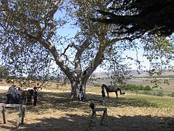
The Capt. Dana Tree at the Dana Adobe. Part of the town can be seen in the background.
|
|
 Location in San Luis Obispo County and the state of California |
|
| Location in the United States | |
| Coordinates: 35°1′48″N 120°29′24″W / 35.03000°N 120.49000°WCoordinates: 35°1′48″N 120°29′24″W / 35.03000°N 120.49000°W | |
| Country |
|
| State |
|
| County | San Luis Obispo |
| Named for | (Chumash: Nipumu', "Village" ) |
| Area | |
| • Total | 14.852 sq mi (38.467 km2) |
| • Land | 14.852 sq mi (38.466 km2) |
| • Water | 0 sq mi (0.001 km2) 0% |
| Elevation | 331 ft (101 m) |
| Population (2010) | |
| • Total | 16,714 |
| • Density | 1,100/sq mi (430/km2) |
| Time zone | Pacific (PST) (UTC-8) |
| • Summer (DST) | PDT (UTC-7) |
| ZIP code | 93444 |
| Area code(s) | 805 |
| FIPS code | 06-51476 |
| GNIS feature ID | 1652759 |
Nipomo is a census-designated place (CDP) in San Luis Obispo County, California, United States. The population was 12,626 at the 2000 census, and grew to 16,714 for the 2010 census.
Nipomo is located at 35°1′48″N 120°29′24″W / 35.03000°N 120.49000°W (35.0300, -120.4900).
According to the United States Census Bureau, the CDP has a total area of 14.9 square miles (39 km2), virtually all of it land.
This region experiences warm (but not hot) and dry summers, with no average monthly temperatures above 71.6 °F. According to the Köppen Climate Classification system, Nipomo has a warm-summer Mediterranean climate, abbreviated "Csb" on climate maps.
The 2010 United States Census reported that Nipomo had a population of 16,714. The population density was 1,125.4 people per square mile (434.5/km²). The racial makeup of Nipomo was 12,281 (73.5%) White, 177 (1.1%) African American, 200 (1.2%) Native American, 421 (2.5%) Asian, 33 (0.2%) Pacific Islander, 2,821 (16.9%) from other races, and 781 (4.7%) from two or more races. Hispanic or Latino of any race were 6,645 persons (39.8%).
...
Wikipedia

