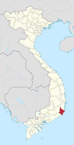
Ninh Thuan Province
|
Ninh Thuận Province Tỉnh Ninh Thuận |
|
|---|---|
| Province | |
 |
|
| Nickname(s): Serenity/Peace | |
 Location of Ninh Thuận within Vietnam |
|
| Coordinates: 11°45′N 108°50′E / 11.750°N 108.833°ECoordinates: 11°45′N 108°50′E / 11.750°N 108.833°E | |
| Country |
|
| Region | South Central Coast |
| Capital | Phan Rang–Tháp Chàm |
| Government | |
| • People's Council Chair | Nguyễn Đức Thanh |
| • People's Committee Chair | Lưu Xuân Vĩnh |
| Area | |
| • Total | 3,358 km2 (1,297 sq mi) |
| Population (2009) | |
| • Total | 565,700 |
| • Density | 170/km2 (440/sq mi) |
| Demographics | |
| • Ethnicities | Kinh, Chăm, Ra Glai, Cơ Ho, Hoa |
| Time zone | ICT (UTC+7) |
| Calling code | +8468 |
| ISO 3166 code | VN-36 |
| Website | www |
Ninh Thuận (Vietnamese: [nɨn tʰwə̂ˀŋ]) is a province in the South Central Coast region of Vietnam (sometimes seen as part of the Southeast region).
The Cham principality of Panduranga had its center in Ninh Thuận Province, but also included much of what is now Bình Thuận Province. Panduranga became the political centre of Champa after the fall of Vijaya in 1471. It remained independent until 1832, when emperor Minh Mạng annexed it. Ninh Thuận was merged into Bình Thuận Province in 1976, together with Bình Tuy Province, Ninh Thuận became a separate province again in 1991.
Ninh Thuận's topography is typical for the South Central Coast in that high mountains are located not only near western border to the Central Highlands, but also near the coast, the highest of which is Chua mountain (núi Chúa) at 1040m in the north-east of the province. Several other peaks with heights up to 643m (Da Bac mountain/núi Đá Bạc in the south) are located along the coast. The highest mountains are located at the borders to Khánh Hòa Province and Lâm Đồng Province, with three mountains of over 1600 and the highest at 1652m (Suong Mu mountain, Núi Sương Mù). Only a small part of the province around Phan Rang has elevations of under 50m. The province's major river is Dinh River, which flows through the main lowland of the province as well as Phan Rang. It has several tributaries in the province and is connected to Don Duong Lake in Lâm Đồng Province.
...
Wikipedia
