Nicasio, CA
| Nicasio, California | |
|---|---|
| Census designated place | |

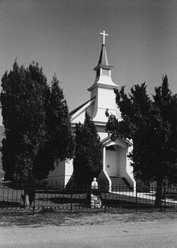
St. Mary's Church, Nicasio, California.
|
|
| Location in California | |
| Coordinates: 38°03′42″N 122°41′55″W / 38.06167°N 122.69861°WCoordinates: 38°03′42″N 122°41′55″W / 38.06167°N 122.69861°W | |
| Country |
|
| State |
|
| County | Marin County |
| Area | |
| • Total | 1.305 sq mi (3.380 km2) |
| • Land | 1.305 sq mi (3.380 km2) |
| • Water | 0 sq mi (0 km2) 0% |
| Elevation | 194 ft (59 m) |
| Population (April 1, 2010) | |
| • Total | 96 |
| • Density | 74/sq mi (28/km2) |
| Time zone | Pacific (UTC-8) |
| • Summer (DST) | PDT (UTC-7) |
| ZIP code | 94946 |
| Area codes | 415/628 |
| FIPS code | 06-51280 |
| GNIS feature IDs | 1659226, 2628764 |
| U.S. Geological Survey Geographic Names Information System: Nicasio, California; U.S. Geological Survey Geographic Names Information System: Nicasio, California | |
Nicasio (/nᵻˈkɑːsi.oʊ/ ni-KAH-see-oh) is a census designated place in Marin County, California. It is located 8 miles (13 km) west-southwest of Novato, at an elevation of 194 feet (59 m).
The Nicasio region is a hydrologic zone containing the four main drainages of Nicasio Creek up to the ridgelines defining their basin. This includes: the south fork of Nicasio Creek extending from Moon Hill, along the ridge separating Nicasio from San Geronimo and Samuel P. Taylor State Park, and extending northwest towards the northern end of Platform Bridge Road; the east fork (Lucas Valley fork) of Nicasio Creek extending from Loma Alta and the ridge on the north side of Sir Francis Drake Boulevard, extending up through Big Rock and up towards Big-Rock Ridge; the Halleck Creek drainage, up to the ridges separating Nicasio from Novato; the northern drainages extending along the ridgelines of Rocky Ridge, Hicks Mountain and Black Mountain.
A major landmark in the area is the man-made Nicasio Reservoir. Nicasio is scenically very attractive with forested and open ridgelines surrounding a wide rolling valley. The area along Lucas Valley Road follows a narrow valley with mostly forested hillsides above it. Oak, bay, and fir trees are common in the area, and along some of the creeks stands of redwoods are still found. Wildlife is abundant; the Nicasio chickadee, a subspecies of the chestnut-backed chickadee, was named by Robert Ridgway. Three main roads cross the area: Lucas Valley Road, Nicasio Valley Road, and the Point Reyes-Petaluma Road. Important pieces of public land in the surrounding area include Point Reyes National Seashore, portions of the Golden Gate National Recreation Area, and Samuel P. Taylor State Park.
...
Wikipedia

