Niagara, New York
| Niagara, New York | |
|---|---|
| Town | |
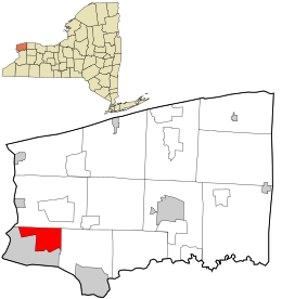
 Location in Niagara County and the state of New York. |
|
| Coordinates: 43°6′58″N 78°59′22″W / 43.11611°N 78.98944°WCoordinates: 43°6′58″N 78°59′22″W / 43.11611°N 78.98944°W | |
| Country | United States |
| State | New York |
| County | Niagara |
| Government | |
| • Type | Town Council |
| • Town Supervisor | Steven C. Richards (R) |
| • Town Council |
Members' List
|
| Area | |
| • Total | 9.4 sq mi (24.3 km2) |
| • Land | 9.4 sq mi (24.3 km2) |
| • Water | 0.0 sq mi (0.0 km2) |
| Elevation | 623 ft (190 m) |
| Population (2010) | |
| • Total | 8,378 |
| • Density | 883.4/sq mi (341.1/km2) |
| Time zone | Eastern (EST) (UTC-5) |
| • Summer (DST) | EDT (UTC-4) |
| FIPS code | 36-51033 |
| GNIS feature ID | 0979275 |
Niagara is a town in Niagara County, New York, United States. As of the 2010 census, the town had a total population of 8,378. The town is named after the famous waterfall Niagara Falls.
The Town of Niagara is the neighbor to the City of Niagara Falls, which is next to the famed Niagara Falls. The town is located in the southwest corner of the county. Since the late 20th century, it has been known for its factory-outlet mall (formerly Prime Outlet Niagara Falls), and is frequently visited by nearby Canadians based on the favorable currency exchange. Also located within the town is Niagara Falls International Airport, which serves the Niagara County area.
It is served by the LaSalle Post Office on Niagara Falls Boulevard (U.S. Route 62) in adjacent Niagara Falls, New York. Residents use a mailing address of "Niagara Falls, NY" because of this. Neither "Niagara, NY," nor "Town of Niagara, NY" are acceptable postal addresses, according to the United States Postal Service.
The Town of Niagara was founded in 1812 (originally as the "Town of Schlosser" after the local fortification Fort Schlosser and after Captain Joseph Schlosser, a German officer in the British Army) from the Town of Cambria. In 1836 western parts of the town were organized as the Town of Wheatfield, New York.
In 1892, the City of Niagara Falls was formed from the eastern end of town, taking about half of its land. In 1903, the city annexed another quarter of the town, reducing its size to 9.4 square miles. Its borders have remained the same since.
...
Wikipedia
