Newtown Creek
| Newtown Creek | |
| Estuary | |
|
The Creek in Long Island City
|
|
| Country | United States |
|---|---|
| State | New York |
| Municipality | New York City |
| Tributaries | |
| - left | English Kills, Whale Creek |
| - right | Maspeth Creek, Dutch Kills |
| Source | Grand Avenue and 47th Street |
| - coordinates | 40°43′06″N 73°55′27″W / 40.718412°N 73.924127°W |
| Mouth | East River |
| - location | 2nd Street and 54th Avenue in Long Island City |
| - elevation | 0 ft (0 m) |
| - coordinates | 40°44′14″N 73°57′40″W / 40.73734°N 73.96112°WCoordinates: 40°44′14″N 73°57′40″W / 40.73734°N 73.96112°W |
| Length | 3.5 mi (6 km) |
| Discharge | |
| - average | 59.3 cu ft/s (2 m3/s) |
|
Newtown Creek and its tributaries
|
|
Newtown Creek, a 3.5-mile (6-kilometer) long tributary of the East River, is an estuary that forms part of the border between the boroughs of Brooklyn and Queens, in New York City. Channelization made it one of the most heavily used bodies of water in the Port of New York and New Jersey and thus one of the most polluted industrial sites in the US, containing years of discarded toxins, an estimated 30,000,000 US gallons (110,000,000 l; 25,000,000 imp gal) of spilled oil, including the Greenpoint oil spill, raw sewage from New York City’s sewer system, and other accumulation from a total of 1,491 sites.
Newtown Creek was proposed as a potential Superfund site in September 2009, and received that designation on September 27, 2010.
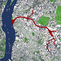
The creek begins near the intersection of 47th Street and Grand Avenue on the Brooklyn-Queens border at the intersection of the East Branch and English Kills. It empties into the East River at 2nd Street and 54th Avenue in Long Island City, opposite Bellevue Hospital in Manhattan at 26th Street. Its waterfront, and that of its tributaries Dutch Kills, Whale Creek, Maspeth Creek and English Kills, are heavily industrialized.
Because the surrounded neighborhoods are completely sewerized, the creek has little natural inflow of natural freshwater. Its outgoing flow of 14 billion US gallons (53,000,000 m3) per year consists of combined sewer overflow, urban runoff, raw domestic sewage, and industrial wastewater. The creek is largely stagnant, one cause being the 15-foot-thick (4.6 m) layer (in some places 25 feet (7.6 m)) of polluted sludge that has congealed on the creek bed.
...
Wikipedia


