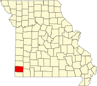
Newton County, Missouri
| Newton County, Missouri | |
|---|---|

Newton County Courthouse in Neosho
|
|
 Location in the U.S. state of Missouri |
|
 Missouri's location in the U.S. |
|
| Founded | December 15, 1838 |
| Seat | Neosho |
| Largest city | Neosho |
| Area | |
| • Total | 627 sq mi (1,624 km2) |
| • Land | 625 sq mi (1,619 km2) |
| • Water | 1.8 sq mi (5 km2), 0.3% |
| Population (est.) | |
| • (2015) | 58,615 |
| • Density | 93/sq mi (36/km²) |
| Congressional district | 7th |
| Time zone | Central: UTC-6/-5 |
| Website | www |
| Newton County, Missouri | ||||
|---|---|---|---|---|
| Elected countywide officials | ||||
| Assessor | Gloria Gourley | Republican | ||
| Circuit Clerk | Patty Krueger | Republican | ||
| County Clerk | Kay Baum | Republican | ||
| Collector | James Otey | Republican | ||
|
Commissioner (Presiding) |
Marilyn Ruestman | Republican | ||
|
Commissioner (District 1) |
Jerry Black | Republican | ||
|
Commissioner (District 2) |
Jack Sanders | Republican | ||
| Coroner | Mark Bridges | Republican | ||
| Prosecuting Attorney | Jacob Skouby | Republican | ||
| Public Administrator | Diane Dodson | Republican | ||
| Recorder | Lenora Hyder | Republican | ||
| Sheriff | Ken Copeland | Republican | ||
| Surveyor | James Loncarich | Republican | ||
| Treasurer | Gina Rodriguez | Republican | ||
Newton County is a county located in the southwest portion of the U.S. state of Missouri. As of the 2010 census, the population was 58,114. Its county seat is Neosho. The county was organized in 1838 and is named in honor of John Newton, a hero who fought in the Revolutionary War.
Newton County is part of the Joplin, MO Metropolitan Statistical Area.
According to the U.S. Census Bureau, the county has a total area of 627 square miles (1,620 km2), of which 625 square miles (1,620 km2) is land and 1.8 square miles (4.7 km2) (0.3%) is water.
Total lake area: 2,573 acres (10.4 km2)
Total river area: 361 acres (1.5 km2); length: 70 miles (110 km)
As of the census of 2000, there were 52,636 people, 20,140 households, and 14,742 families residing in the county. The population density was 84 people per square mile (33.75/km²). There were 21,897 housing units at an average density of 35 per square mile (14/km²). The racial makeup of the county was 93.26% White, 0.59% Black or African American, 2.23% Native American, 0.32% Asian, 0.28% Pacific Islander, 1.12% from other races, and 2.20% from two or more races. 2.18% of the population were Hispanic or Latino of any race.
...
Wikipedia
