Newington, Connecticut
| Newington, Connecticut | ||
|---|---|---|
| Town | ||

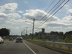
A view of the Berlin Turnpike
|
||
|
||
 Location within Hartford County, Connecticut |
||
| Coordinates: 41°41′14″N 72°43′48″W / 41.68722°N 72.73000°WCoordinates: 41°41′14″N 72°43′48″W / 41.68722°N 72.73000°W | ||
| Country |
|
|
| State |
|
|
| NECTA | Hartford | |
| Region | Capitol Region | |
| Incorporated | 1871 | |
| Government | ||
| • Type | Council-manager | |
| • Town manager | Tanya Lane, Acting Town Manager | |
| • Council |
Roy Zartarian (R), Mayor Diana Casasanta Serra (D) Tim Manke (R) Beth DelBuono (R) Maureen Klett (R) James Marocchini (D) Gail Budrejko (R) David Nagel (R) |
|
| Area | ||
| • Total | 13.1 sq mi (34.0 km2) | |
| • Land | 13.1 sq mi (34.0 km2) | |
| • Water | 0.0 sq mi (0.0 km2) | |
| Elevation | 85 ft (26 m) | |
| Population (2010) | ||
| • Total | 30,562 | |
| • Density | 2,248/sq mi (868/km2) | |
| Time zone | Eastern (UTC-5) | |
| • Summer (DST) | Eastern (UTC-4) | |
| ZIP code | 06111 | |
| Area code(s) | 860 | |
| FIPS code | 09-52140 | |
| GNIS feature ID | 0213472 | |
| Website | www |
|
Roy Zartarian (R), Mayor
Newington is a town in Hartford County, Connecticut, United States. Located 8 miles (13 km) south of downtown Hartford, Newington is an older, mainly residential suburb located in Greater Hartford. As of the 2010 census, it had a population of 30,562. The Connecticut Department of Transportation has its headquarters in Newington.
Newington is home to Mill Pond Falls, near the center of town. It is celebrated each fall during the Waterfall Festival.
The American Radio Relay League is headquartered in Newington, with a call sign of W1AW.
Newington has a history of nearly 375 years. While not established officially as a separate town until 1871, settlers from nearby Wethersfield took up residence on the western frontier of their riverside town in 1636. “West Society,” as some called it, was an area rich in timber that was used for pipe staves, barrel-sized containers used for colonial trade. Grand pastures also made the land ideal for herding and grazing cattle. Its inhabitants received land grants from Wethersfield leaders. Known as “West Farms,” the area west of the central portion of Wethersfield became settled by those who were almost exclusively the descendants of the earliest Wethersfield settlers. In 1721, the “western” farmers requested that the General Assembly of the Connecticut Colony give their land the name “Newington” to denote “the new town in the meadow.” The Assembly granted the request, even though it took another 150 years before Newington officially became an incorporated town. The town’s name predates its official existence.
Newington’s motto inscribed on its town seal is “growth and progress,” which it began putting into effect at the end of the eighteenth century. In 1798, the precursor to the Berlin Turnpike was authorized and it changed the complexion of the land by dividing the vast farmlands from the commercial center. Originally called the Hartford and New Haven Turnpike, the route attracted a number of businesses from north to south between Hartford and New Haven.
...
Wikipedia

