Newfound Gap
| Newfound Gap | |
|---|---|

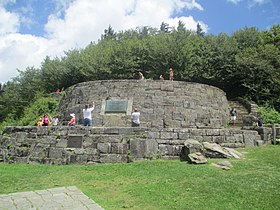
Rockefeller Memorial at Newfound Gap
|
|
| Elevation | 5,048 ft (1,539 m) |
| Traversed by | Newfound Gap Road Appalachian Trail |
| Location |
|
| Range | Great Smoky Mountains |
| Coordinates | 35°36′40″N 83°25′30″W / 35.6112063°N 83.4248814°WCoordinates: 35°36′40″N 83°25′30″W / 35.6112063°N 83.4248814°W |
| Topo map | USGS Clingmans Dome |
| Newfound Gap Road | |
|---|---|
| Route information | |
| Maintained by NPS | |
| Length: | 31.6 mi (50.9 km) |
| Major junctions | |
| South end: |
|
| North end: |
|
| Location | |
| States: | North Carolina, Tennessee |
| Counties: | Swain, NC; Sevier, TN |
| Highway system | |
|
|
|
Newfound Gap (el. 5048 ft./1539 m.) is a mountain pass located near the center of the Great Smoky Mountains National Park of the southern Appalachian Mountains in the United States of America. Situated along the border of Tennessee and North Carolina, the state line crosses the gap, as does Newfound Gap Road (which overlaps U.S. Route 441 through the park and ends at the park's boundaries near Gatlinburg, Tennessee and Cherokee, North Carolina). The Appalachian Trail also traverses the gap, as do a small number of other hiking trails.
Newfound Gap is also home to the Rockefeller Memorial, a popular destination within the national park and the site from where former U.S. President Franklin D. Roosevelt formally dedicated the park on September 2, 1940.
According to the National Weather Service, Newfound Gap has around 19 snowy days per year, comparable to 18 at Minneapolis, Minnesota. From 1991 to 2005, annual snowfall ranged from 43.5 inches (110 cm) to 106 inches (270 cm).
...
Wikipedia

