Newfield, New Jersey
| Newfield, New Jersey | |
|---|---|
| Borough | |
| Borough of Newfield | |
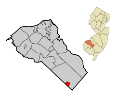
 Map of Newfield highlighted within Gloucester County. Inset: Location of Gloucester County in New Jersey. |
|
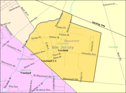
 Census Bureau map of Newfield, New Jersey |
|
| Coordinates: 39°33′03″N 75°00′37″W / 39.550847°N 75.010258°WCoordinates: 39°33′03″N 75°00′37″W / 39.550847°N 75.010258°W | |
| Country | |
| State |
|
| County |
|
| Incorporated | March 8, 1924 |
| Government | |
| • Type | Borough |
| • Body | Borough Council |
| • Mayor | Donald Sullivan (R, term ends December 31, 2018) |
| • Clerk | Toni Van Camp |
| Area | |
| • Total | 1.706 sq mi (4.418 km2) |
| • Land | 1.703 sq mi (4.410 km2) |
| • Water | 0.003 sq mi (0.008 km2) 0.18% |
| Area rank | 430th of 566 in state 19th of 24 in county |
| Elevation | 118 ft (36 m) |
| Population (2010 Census) | |
| • Total | 1,553 |
| • Estimate (2015) | 1,534 |
| • Rank | 512th of 566 in state 24th of 24 in county |
| • Density | 912.0/sq mi (352.1/km2) |
| • Density rank | 397th of 566 in state 15th of 24 in county |
| Time zone | Eastern (EST) (UTC-5) |
| • Summer (DST) | Eastern (EDT) (UTC-4) |
| ZIP code | 08344 |
| Area code(s) | 856 |
| FIPS code | 3401551390 |
| GNIS feature ID | 0885319 |
| Website | www |
Newfield is a borough in Gloucester County, New Jersey, United States. As of the 2010 United States Census, the borough's population was 1,553, reflecting a decline of 63 (-3.9%) from the 1,616 counted in the 2000 Census, which had in turn increased by 24 (+1.5%) from the 1,592 counted in the 1990 Census.
Newfield was formed as a borough by an act of the New Jersey Legislature on March 8, 1924, from portions of Franklin Township, based on the results of a referendum held on April 1, 1924. In the weeks before the legislature approved the formation of the borough, a group of 240 residents traveled to Trenton by train to lobby on behalf of the creation of an independent municipality. The borough's name derives from its status as a new-field development.
According to the United States Census Bureau, the borough had a total area of 1.706 square miles (4.418 km2), including 1.703 square miles (4.410 km2) of land and 0.003 square miles (0.008 km2) of water (0.18%).
The borough borders Franklin Township and Cumberland County.
As of the 2010 United States Census, there were 1,553 people, 579 households, and 452.8 families residing in the borough. The population density was 912.0 per square mile (352.1/km2). There were 626 housing units at an average density of 367.6 per square mile (141.9/km2). The racial makeup of the borough was 94.66% (1,470) White, 2.19% (34) Black or African American, 0.26% (4) Native American, 0.32% (5) Asian, 0.00% (0) Pacific Islander, 0.97% (15) from other races, and 1.61% (25) from two or more races. Hispanic or Latino of any race were 6.57% (102) of the population.
...
Wikipedia
