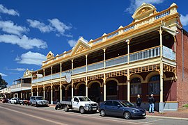
Newcastle, Western Australia
|
Toodyay Western Australia |
|
|---|---|

View of Stirling Terrace, 2013
|
|
| Coordinates | 31°33′S 116°27′E / 31.550°S 116.450°ECoordinates: 31°33′S 116°27′E / 31.550°S 116.450°E |
| Population | 4,686 |
| Established | 1860 |
| Postcode(s) | 6566 |
| Location | |
| LGA(s) | Shire of Toodyay |
| State electorate(s) | Moore |
| Federal Division(s) | Pearce |
Toodyay (Noongar: Duidgee), known as Newcastle between 1860 and 1910, is a town on the Avon River in the Wheatbelt region of Western Australia, 85 kilometres (53 mi) north-east of Perth on Ballardong Nyoongar land. The first European settlement occurred in the area in 1836. After flooding in the 1850s, the townsite was moved to its current location in the 1860s. It is connected by railway and road to Perth. During the 1860s, it was home to bushranger Moondyne Joe.
The original village of Toodyay was one of the earliest inland towns in Western Australia. A habitat of the Ballardong Noongar people for thousands of years, the Avon River valley was discovered by Ensign Robert Dale in 1830, leading to exploration by settlers including James Drummond, Captain Francis Whitfield and Alexander Anderson. The first village was established in 1836. Drummond established his homestead Hawthornden nearby. The original location is subject to flooding, which led to its abandonment in the 1850s, and a new townsite was established on higher ground 2 kilometres (1.2 mi) upstream. This was proclaimed by Governor Arthur Kennedy on 1 October 1860 as "Newcastle" and the original settlement came to be referred to as "Old Toodyay". In May 1910, due to confusion with the New South Wales city of Newcastle, a name-change to Toodyay was proposed and the original townsite, which had by this time declined substantially, became "West Toodyay".
...
Wikipedia

