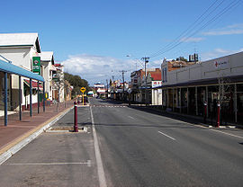
Northam, Western Australia
|
Northam Western Australia |
|||||||
|---|---|---|---|---|---|---|---|
 |
|||||||
| Coordinates | 31°39′11″S 116°39′58″E / 31.65306°S 116.66611°ECoordinates: 31°39′11″S 116°39′58″E / 31.65306°S 116.66611°E | ||||||
| Population | 6,580 (2011 census) | ||||||
| Established | 1833 | ||||||
| Postcode(s) | 6401 | ||||||
| Elevation | 170 m (558 ft) | ||||||
| Location | 96 km (60 mi) from Perth | ||||||
| LGA(s) | Shire of Northam | ||||||
| State electorate(s) | Central Wheatbelt | ||||||
| Federal Division(s) | Pearce | ||||||
|
|||||||
Northam /ˈnɔːrðəm/ is a town in Western Australia, situated at the confluence of the Avon and Mortlock Rivers, about 97 kilometres (60 mi) east-northeast of Perth in the Avon Valley. At the 2011 census, Northam had a population of 6,580. Northam is the largest town in the Avon region. It is also the largest inland town in the state not founded on mining.
The area around Northam was first explored in 1830 by a party of colonists led by Ensign Robert Dale, and subsequently founded in 1833. It was named by Governor Stirling, probably after a village of the same name in Devon, England. Almost immediately it became a point of departure for explorers and settlers who were interested in the lands which lay to the east.
This initial importance declined with the growing importance of the nearby towns of York and Beverley, but the arrival of the railway made Northam the major departure point for prospectors and miners heading east towards the goldfields.
A number of older buildings have local heritage significance and still serve the community.
Northam Flour Mill and Avon Bridge
Northam Town Hall (constr. 1898-1904), Henry James Procktor arch.
St John's Church (1890), Charles Bird arch.
Northam Post Office (1909), Hilton Beasley arch.
...
Wikipedia

