New York State Route 408
| New York State Route 408 | |||||||
|---|---|---|---|---|---|---|---|

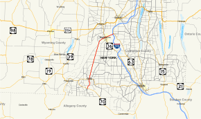
Map of Livingston County in western New York with NY 408 highlighted in red
|
|||||||
| Route information | |||||||
| Maintained by NYSDOT | |||||||
| Length: | 15.95 mi (25.67 km) | ||||||
| Existed: | early 1940s – present | ||||||
| Major junctions | |||||||
| South end: |
|
||||||
|
|
|||||||
| North end: |
|
||||||
| Location | |||||||
| Counties: | Livingston | ||||||
| Highway system | |||||||
|
|||||||
| New York State Route 408A | |
|---|---|
| Location: | Angelica–Dalton |
| Existed: | early 1940s–1949 |
New York State Route 408 (NY 408) is a 15.95-mile (25.67 km) state highway located entirely within Livingston County, New York, in the United States. It runs north–south from an intersection with NY 70 near the hamlet of Dalton in the town of Nunda to a junction with NY 63 in the town of Groveland near NY 408's exit with Interstate 390 (I-390). Most of NY 408 is a two-lane rural highway that passes through lightly developed areas; however, the last two miles (3 km) of the highway, where it runs in a due east–west direction, are heavily trafficked as NY 408 becomes a key connector road in both directions.
The origins of NY 408 date back to the early 20th century when the portion of the route north of the village of Nunda became part of two unsigned legislative routes. One of the two, Route 15, utilized the segment of modern NY 408 northeast of Mount Morris, and this segment became part of the signed NY 36 in the mid-1920s. Most of the route remained unnumbered until the 1930 renumbering of state highways in New York, however, at which time NY 36 was moved off the highway and all of what is now NY 408 became part of NY 63. That route was realigned as well in the early 1940s to head southeast from Mount Morris to Dansville, giving way to NY 408.
...
Wikipedia

