New York State Route 352
| New York State Route 352 | |||||||
|---|---|---|---|---|---|---|---|

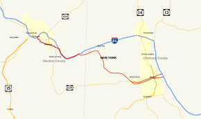
Map of Southern Tier in New York with NY 352 highlighted in red
|
|||||||
| Route information | |||||||
| Maintained by NYSDOT and the city of Elmira | |||||||
| Length: | 18.96 mi (30.51 km) | ||||||
| Existed: | mid-1960s – present | ||||||
| Major junctions | |||||||
| West end: |
|
||||||
|
|
|||||||
| East end: |
|
||||||
| Location | |||||||
| Counties: | Steuben, Chemung | ||||||
| Highway system | |||||||
|
|||||||
New York State Route 352 (NY 352) is a state highway in the Southern Tier of New York in the United States. It generally parallels the Southern Tier Expressway (Interstate 86 or I-86 and NY 17) from the village of Riverside (exit 45) east through the city of Corning to the city of Elmira (exit 56). The portion of NY 352 west of the hamlet of Big Flats was once part of NY 17; the rest was originally New York State Route 17E. Construction of and improvements to the Southern Tier Expressway have resulted in extensions of NY 352, primarily along the former NY 17 right-of-way.
NY 352 begins at an intersection with NY 415 (High Street) in village of Riverside. NY 352 proceeds southward along Buffalo Street, a two-lane commercial street for two blocks to an intersection with Denison Parkway. At the Denison Parkway intersection, NY 352 turns east along Denison, while to the west is an interchange with the I-86 and NY 17 (the Southern Tier Expressway). NY 352 now proceeds eastward on Denison Parkway, a four-lane boulevard alongside the Chemung River. After bending southeast and crossing into the Chemung, the route leaves the village of Riverside for the city of Corning.
...
Wikipedia

