New York State Route 244
| New York State Route 244 | ||||
|---|---|---|---|---|

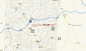
Map of Allegany County in the Southern Tier of New York with NY 244 highlighted in red
|
||||
| Route information | ||||
| Maintained by NYSDOT | ||||
| Length: | 15.80 mi (25.43 km) | |||
| Existed: | 1930 – present | |||
| Major junctions | ||||
| West end: |
|
|||
| East end: |
|
|||
| Location | ||||
| Counties: | Allegany | |||
| Highway system | ||||
|
||||
New York State Route 244 (NY 244) is an east–west state highway in Allegany County, New York, in the United States. It runs for 15.80 miles (25.43 km) from an intersection with NY 19 in the village of Belmont to a junction with NY 21 in the town of Alfred. The highway is located about 3 miles (4.8 km) south of the Southern Tier Expressway (Interstate 86 or I-86 and NY 17), which loosely parallels NY 244 between Belmont and Alfred. NY 244 was assigned as part of the 1930 renumbering of state highways in New York.
NY 244 begins at an intersection with NY 19 in the village of Belmont, located 3 miles (4.8 km) southeast of the Southern Tier Expressway (Interstate 86 or I-86 and NY 17) in the town of Amity. The route heads northeast on the two-lane Genesee Street, serving several blocks of homes as it crosses the Western New York and Pennsylvania Railroad at-grade and passes over the Genesee River. On the opposite bank, NY 244 changes names to Milton Street at an intersection with the south end of County Route 48 (CR 48, named Triana Street). From here, the route continues northeastward out of the village and into less developed areas of Amity. Outside the village limits, the route becomes Mainville Road and runs mostly parallel to Phillips Creek, following it northeast and eastward through a lightly populated valley. The highway meets the southern terminus of CR 2B (Baker Valley Road) on its way into the town of Ward, where NY 244 loses the Mainville Road name and the creek ends in the hamlet of Phillips Creek.
...
Wikipedia

