New York State Route 18D
| New York State Route 182 | |||||||
|---|---|---|---|---|---|---|---|

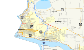
Map of Niagara County in western New York with NY 182 highlighted in red
|
|||||||
| Route information | |||||||
| Maintained by NYSDOT and the city of Niagara Falls | |||||||
| Length: | 6.18 mi (9.95 km) | ||||||
| Existed: | January 1, 1962 – present | ||||||
| Major junctions | |||||||
| West end: | Whirlpool Rapids Bridge in Niagara Falls | ||||||
|
|
|||||||
| East end: |
|
||||||
| Location | |||||||
| Counties: | Niagara | ||||||
| Highway system | |||||||
|
|||||||
New York State Route 182 (NY 182) is a 6.18-mile (9.95 km) state highway in Niagara County, New York, in the United States. It serves as a signed connection between the Whirlpool Rapids Bridge over the Niagara River and the Niagara Falls International Airport east of the city of Niagara Falls. From the bridge, NY 182 runs across the city of Niagara Falls, following several local streets as it makes its way to an intersection with U.S. Route 62 (US 62) in Wheatfield. The route was originally designated as New York State Route 18D in the early 1930s. It gained its current designation on January 1, 1962.
NY 182 begins at Whirlpool Street's intersection with the Whirlpool Rapids Bridge in the northern part of Niagara Falls near the Niagara Falls Amtrak station. From here, the route heads south on Whirlpool Street, a two-lane, at-grade road that parallels the Robert Moses State Parkway through most of the city. After two residential blocks, the route turns east onto Cleveland Avenue, leaving the vicinity of the Niagara River and entering a mixed-use area surrounding Cleveland Avenue's nearby intersection with Main Street (NY 104). Past this junction, NY 182 passes two more blocks of homes before veering northeast onto Lockport Street. The route turns again just two blocks later to proceed east on Ontario Avenue.
...
Wikipedia

