New York State Highway 14
| New York State Route 14 | ||||
|---|---|---|---|---|

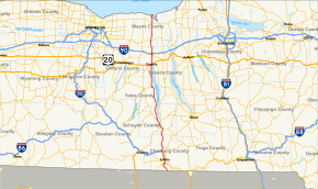
Map of central New York with NY 14 highlighted in red
|
||||
| Route information | ||||
| Maintained by NYSDOT and the cities of Elmira and Geneva | ||||
| Length: | 95.24 mi (153.27 km) | |||
| Existed: | 1924 – present | |||
| Major junctions | ||||
| South end: |
|
|||
|
|
||||
| North end: | Greig Street cul-de-sac in Sodus Point | |||
| Location | ||||
| Counties: | Chemung, Schuyler, Yates, Ontario, Wayne | |||
| Highway system | ||||
|
||||
|
New York State Route 14 Truck |
|
|---|---|
| Location: | Geneva |
New York State Route 14 (NY 14) is a state highway located in western New York in the United States. Along with NY 19, it is one of two routes to transect the state in a north–south fashion between the Pennsylvania border and Lake Ontario. The southern terminus is at the state line in the Chemung County town of Ashland, where it continues south as Pennsylvania Route 14 (PA 14). Its northern terminus is at a cul-de-sac on Greig Street in the Wayne County village of Sodus Point. NY 14 has direct connections with every major east–west highway in western New York, including Interstate 86 (I-86) and NY 17, U.S. Route 20 (US 20) and NY 5, and the New York State Thruway (I-90). It passes through two cities—Elmira and Geneva—and serves many villages as it traverses the state.
...
Wikipedia

