New Radnor
New Radnor
|
|
|---|---|
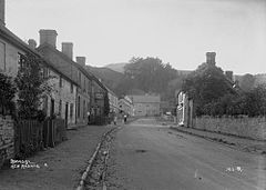
 Broad St. New Radnor, c.1900 |
|
| New Radnor shown within Powys | |
| Population | 409 (2011) |
| OS grid reference | SO212609 |
| Principal area | |
| Ceremonial county | |
| Country | Wales |
| Sovereign state | United Kingdom |
| Post town | PRESTEIGNE |
| Postcode district | LD8 |
| Dialling code | 01544 |
| Police | Dyfed-Powys |
| Fire | Mid and West Wales |
| Ambulance | Welsh |
| EU Parliament | Wales |
| UK Parliament | |
New Radnor (Welsh: Maesyfed) is a village in Powys, mid Wales. It was the original county town of Radnorshire. In the 2001 census, the community had a population of 410, split evenly between male and female, living in 192 households. The population at the 2011 Census had decreased slightly to 409.
The village lies by the Radnor Forest and has been said to have been built to replace Old Radnor. It was a planned medieval walled town with streets laid out in a grid pattern. It was linked to other settlements nearby and regionally such as Builth, Presteigne and Kington Castle and later Huntington Castle near Gladestry.
Attractions in the town include a significant castle [1] mound of a Norman motte [2]. New Radnor castle was originally called Trefaesyfed and was once a considerable fortress and a significant border castle in the Welsh Marches and played its part in the turmoil, violence and barbarity of the early medieval period typical of such a site.
The first castle at New Radnor may have been built by William Fitz Osbern earl of Hereford. Certainly he held the land by the time of his death in 1071 and the layout of the powerful castle suggests that it was built by a man of great influence. Soon after 1086 New Radnor was granted to Philip de Braose. It may have been at this time that ten minor castles were built nearby to strengthen the Norman hold on the district.
...
Wikipedia

