New Providence, New Jersey
| New Providence, New Jersey | |
|---|---|
| Borough | |
| Borough of New Providence | |

A public space for outdoor ceremonies
|
|
 Map of New Providence in Union County. Inset: Location of Union County in New Jersey |
|
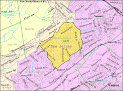
 Census Bureau map of New Providence, New Jersey |
|
| Coordinates: 40°41′56″N 74°24′24″W / 40.69889°N 74.406623°WCoordinates: 40°41′56″N 74°24′24″W / 40.69889°N 74.406623°W | |
| Country |
|
| State |
|
| County | Union |
| Incorporated | March 14, 1899 |
| Government | |
| • Type | Borough |
| • Body | Borough Council |
| • Mayor | Allen B. Morgan (R, term ends December 31, 2018) |
| • Administrator | Douglas R. Marvin |
| • Clerk | Wendi B. Barry |
| Area | |
| • Total | 3.665 sq mi (9.492 km2) |
| • Land | 3.640 sq mi (9.428 km2) |
| • Water | 0.025 sq mi (0.064 km2) 0.67% |
| Area rank | 308th of 566 in state 14th of 21 in county |
| Elevation | 217 ft (66 m) |
| Population (2010 Census) | |
| • Total | 12,171 |
| • Estimate (2015) | 12,469 |
| • Rank | 201st of 566 in state 16th of 21 in county |
| • Density | 3,343.4/sq mi (1,290.9/km2) |
| • Density rank | 196th of 566 in state 17th of 21 in county |
| Time zone | Eastern (EST) (UTC-5) |
| • Summer (DST) | Eastern (EDT) (UTC-4) |
| ZIP code | 07974 |
| Area code(s) | 908 and 973 |
| FIPS code | 3403951810 |
| GNIS feature ID | 0885321 |
| Website | www |
New Providence is a borough on the northwestern edge of Union County, New Jersey, United States. It is located on the Passaic River, which forms the county boundary with Morris County. As of the 2010 United States Census, the population was 12,171, reflecting an increase of 264 (+2.2%) from the 11,907 counted in the 2000 Census, which had in turn increased by 468 (+4.1%) from the 11,439 counted in the 1990 Census.
The written history of New Providence begins in 1664 when James, Duke of York and brother to King Charles II, purchased the land that became known as the Elizabethtown Tract from the Lenape Native Americans. Its first European settlers were members of a Puritan colony established in 1720, which was the first permanent settlement of its type. The settlement was originally called "Turkey" or "Turkey Town", due to the presence of wild turkeys in the area.
The Presbyterian Church established in 1737 was a focal point for the community, and the lack of serious injuries when the church's balcony collapsed in 1759 was deemed to be an example of Divine intervention, leading residents to change the area's name to New Providence.
According to local tradition, George Washington spent the night in a local home, which still stands to this day. Supposedly, the local stream, Salt Brook, is named for an incident when the salt supply of the colonial village was dumped into the brook to prevent passing British soldiers from taking it. Ironically, the British Army never crossed the Watchung Mountains into this region. Salt Brook winds through town, starting near the eponymous Salt Brook Elementary School.
...
Wikipedia
