New Jersey Route 50
| Route 50 | ||||
|---|---|---|---|---|

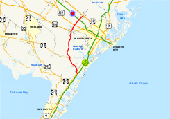
Major highways in Southern New Jersey with NJ 50 in red.
|
||||
| Route information | ||||
| Maintained by NJDOT | ||||
| Length: | 26.02 mi (41.88 km) | |||
| Existed: | 1927 – present | |||
| Major junctions | ||||
| South end: |
|
|||
|
|
||||
| North end: |
|
|||
| Location | ||||
| Counties: | Cape May, Atlantic | |||
| Highway system | ||||
|
||||
New Jersey State Highway Routes
Route 50 is a state highway in the southern part of the U.S. state of New Jersey. It runs 26.02 mi (41.88 km) from an intersection with U.S. Route 9 (US 9) and the Garden State Parkway in Upper Township, Cape May County to an intersection with US 30 and County Route 563 (CR 563) in Egg Harbor City, Atlantic County. The route, which is mostly a two-lane undivided road, passes through mostly rural areas of Atlantic and Cape May counties as well as the communities of Tuckahoe, Corbin City, Estell Manor, and Mays Landing. NJ 50 intersects several roads, including Route 49 in Tuckahoe, US 40 in Mays Landing, and US 322 and the Atlantic City Expressway in Hamilton Township.
...
Wikipedia

