New Haven, Missouri
| New Haven, Missouri | |
|---|---|
| City | |
| Nickname(s): sun drop country | |
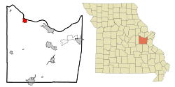
 Location of New Haven, Missouri |
|
| Coordinates: 38°36′18″N 91°13′5″W / 38.60500°N 91.21806°WCoordinates: 38°36′18″N 91°13′5″W / 38.60500°N 91.21806°W | |
| Country | United States |
| State | Missouri |
| County | Franklin |
| Area | |
| • Total | 3.45 sq mi (8.94 km2) |
| • Land | 3.29 sq mi (8.52 km2) |
| • Water | 0.16 sq mi (0.41 km2) |
| Elevation | 676 ft (206 m) |
| Population (2010) | |
| • Total | 2,089 |
| • Estimate (2012) | 2,096 |
| • Density | 635.0/sq mi (245.2/km2) |
| Time zone | Central (CST) (UTC-6) |
| • Summer (DST) | CDT (UTC-5) |
| ZIP code | 63068 |
| Area code(s) | 573 |
| FIPS code | 29-51914 |
| GNIS feature ID | 0731625 |
New Haven is a city in Franklin County, Missouri, United States. The population was 2,008 at the 2010 census.
New Haven is within the Hermann AVA (American Viticultural Area).
New Haven was originally called Miller's Landing, and uner the latter name was platted in 1855. A post office called New Haven has been in operation since 1858. New Haven also claims to be the founding city of Sun Drop and has a Pepsi plant located in it. New Haven is also the home of Pinckney Bend Distillery which has won several international awards for its spirits.
The AME Church of New Haven, New Haven Commercial Historic District, New Haven Residential Historic District, Wilhelm Pelster House-Barn, and Christopher and Johanna Twelker Farm are listed on the National Register of Historic Places.
New Haven is located at 38°36′18″N 91°13′5″W / 38.60500°N 91.21806°W (38.604989, -91.218137).
According to the United States Census Bureau, the city has a total area of 3.45 square miles (8.94 km2), of which, 3.29 square miles (8.52 km2) is land and 0.16 square miles (0.41 km2) is water.
...
Wikipedia
