New Botley
| Botley | |
|---|---|
 Seacourt Tower |
|
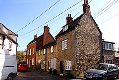
 Old houses in Botley |
|
| Botley shown within Oxfordshire | |
| OS grid reference | SP483060 |
| Civil parish | |
| District | |
| Shire county | |
| Region | |
| Country | England |
| Sovereign state | United Kingdom |
| Post town | Oxford |
| Postcode district | OX2 |
| Dialling code | 01865 |
| Police | Thames Valley |
| Fire | Oxfordshire |
| Ambulance | South Central |
| EU Parliament | South East England |
| UK Parliament | |
Botley is a village in the civil parish of North Hinksey in the ceremonial county of Oxfordshire, just west of the Oxford city boundary. Historically part of Berkshire, it stands on the Seacourt Stream, a stream running off the River Thames. The intersection of the A34 and A420 is to the village's north.
Botley, aside from central offices and a modest row of shops, is a residential suburb of Oxford. Generally house prices are above average for the Oxford area, from average in its east (similar to much of Dean Court), to very expensive towards where the settlement adjoins Cumnor Hill, in its south.
It lies, apart from a small section which is southeast, southwest of the junction between the A34 (Oxford ring road) and the A420 westward to Swindon.
The contiguous neighbourhood Dean Court adjoins Botley to its west, in the Cumnor civil parish. The other settlements which merge into this settlement are North Hinksey and Cumnor Hill.
Elevations range from 56m on the Hinksey Stream marking much of the eastern border to the western border which ranges from 80 to 120m AOD from north to south. The southern point is a border of Cumnor Hill and adjoins Matthew Arnold School.
Botley shops comprise Elms Parade and the West Way shopping precinct.
...
Wikipedia

