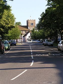
New Alresford
| New Alresford | |
|---|---|
 Broad Street, New Alresford |
|
| New Alresford shown within Hampshire | |
| Population | 6,000 5,431 (2011 Census) |
| OS grid reference | SU 58 32 |
| District | |
| Shire county | |
| Region | |
| Country | England |
| Sovereign state | United Kingdom |
| Post town | ALRESFORD |
| Postcode district | SO24 |
| Dialling code | 01962 |
| Police | Hampshire |
| Fire | Hampshire |
| Ambulance | South Central |
| EU Parliament | South East England |
| UK Parliament | |
New Alresford or simply Alresford (/ˈɒlzfərd/ or /ˈɔːlzfərd/) is a small town and civil parish in the City of Winchester district of Hampshire, England. It is 12 kilometres (7.5 mi) north-east of Winchester and 20 kilometres (12 mi) south-west of the town of Alton. In the 2001 census, Alresford had a population of around 6,000.
New Alresford has shops, a tourist information centre, a central conservation area, two tea rooms and is a terminus as with Alton of the Watercress Line, a steam worked heritage railway at Alresford railway station.
There is evidence of Neolithic, Bronze Age and Iron Age occupation on numerous sites in the Alresford area, with a Roman or Romano-British site on nearby Fobdown and to the south-east of the town in Bramdean. There is evidence of a grant to the Church at Winchester sometime before the 9th century, which became known as the Liberty of Alresford. Alresford was listed in the Domesday Book but this probably refers to what is now Old Alresford as there is no evidence of a settlement south of the river at this time. Old Alresford as with Farnham, Guildford, Dorking and Maidstone adjoins the Pilgrims' Way between Canterbury and Winchester.
...
Wikipedia

