Natrona, Pennsylvania
| Natrona, Pennsylvania | |
|---|---|
| Unincorporated community | |

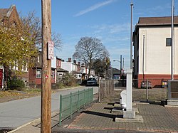
The Pennsalt Historic District, founded c. 1850, in Natrona
|
|
| Location within the state of Pennsylvania | |
| Coordinates: 40°36′52″N 79°43′21″W / 40.61444°N 79.72250°WCoordinates: 40°36′52″N 79°43′21″W / 40.61444°N 79.72250°W | |
| Country | United States |
| State | Pennsylvania |
| County | Allegheny |
| Township | Harrison |
| Elevation | 758 ft (231 m) |
| Time zone | Eastern (EST) (UTC-5) |
| • Summer (DST) | EDT (UTC-4) |
| ZIP codes | 15065 |
| Area code(s) | 724, 878 |
| GNIS feature ID | 1182182 |
| Website | http://harrisontwp.com/ |
Natrona is an unincorporated community in Harrison Township, Allegheny County in the U.S. state of Pennsylvania. It is located in western Pennsylvania within the Pittsburgh Metropolitan Statistical Area, approximately 24 miles (39 km) northeast of Downtown Pittsburgh. Natrona is situated along the Allegheny River at Lock and Dam Four, Pools Three and Four between Brackenridge, Natrona Heights, Karns, Allegheny Township, and Lower Burrell.
The original village of Natrona – then known as East Tarentum – was built as a company town by the Pennsylvania Salt Manufacturing Company in the 1850s. The company began with two salt wells in 1850, and continued operations until 1959. By 1876, the company, which owned the cryolite deposits of Greenland, brought the crude mineral to its works in Natrona, where the mineral was pulverized, sifted, heated, reacted with calcium carbonate and leached to produce pure carbonate of soda (sodium carbonate) and aluminate of soda (sodium aluminate).
...
Wikipedia

