Nathalia
|
Nathalia Victoria |
|||||||||||||||
|---|---|---|---|---|---|---|---|---|---|---|---|---|---|---|---|

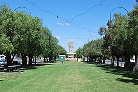
Park in the centre of Blake St, the main street of town
|
|||||||||||||||
| Coordinates | 36°03′30″S 145°12′13″E / 36.05833°S 145.20361°ECoordinates: 36°03′30″S 145°12′13″E / 36.05833°S 145.20361°E | ||||||||||||||
| Population | 1,902 (2011 census) | ||||||||||||||
| Established | 1875 | ||||||||||||||
| Postcode(s) | 3638 | ||||||||||||||
| Location |
|
||||||||||||||
| LGA(s) | Shire of Moira | ||||||||||||||
| State electorate(s) | Shepparton | ||||||||||||||
| Federal Division(s) | Murray | ||||||||||||||
|
|||||||||||||||
Nathalia (/nəˈθeɪliə/ nə-THAY-li-ə) is a town in northern Victoria, Australia. The town is located within the Shire of Moira local government area on the banks of Broken Creek and on the Murray Valley Highway. At the 2011 census, Nathalia had a population of 1,902.
Prior to European settlement, the area around Nathalia was occupied by the Yorta Yorta people. In 1838, Charles Sturt was the first European to explore the area, following the Murray River downstream. The squatter, W.J Locke established Kotupna station on the future site of Nathalia in 1843. The station was broken up for closer settlement in 1869. A selector, Richard Blake took up the townsite in 1875 and established a sawmill and flour mill soon after. Hotels, a post office (opened on 7 September 1878), schools and churches followed and Nathalia was officially gazetted as a village in 1880. The railway arrived in 1888, allowing local production to increase and a butter factory was established in 1895.
...
Wikipedia

