Natashquan River
| Natashquan River | |
| Country | Canada |
|---|---|
| Province | Newfoundland and Labrador, Quebec |
| Source | Unnamed wilderness |
| - location | About 210 km (130 mi) ESE of Labrador City, Newfoundland and Labrador |
| - elevation | 630 m (2,067 ft) |
| - coordinates | 52°31′00″N 63°45′45″W / 52.51667°N 63.76250°W |
| Mouth | Gulf of Saint Lawrence |
| - location | Natashquan FN Reserve, Quebec |
| - elevation | 0 m (0 ft) |
| - coordinates | 50°07′07″N 61°48′26″W / 50.11861°N 61.80722°WCoordinates: 50°07′07″N 61°48′26″W / 50.11861°N 61.80722°W |
| Length | 410 km (255 mi) |
| Basin | 16,100 km2 (6,200 sq mi) |
| Discharge | |
| - average | 410 m3/s (14,480 cu ft/s) |
|
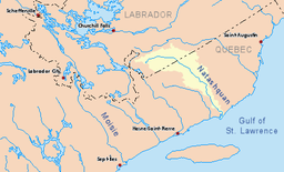
Drainage basin in yellow
|
|
The Natashquan [nəˈtæʃkn] is a river in the Canadian provinces of Quebec and Newfoundland and Labrador.
The river has its source just south of the boundary between the Atlantic and Saint Lawrence river watersheds. It flows south-east to the Labrador–Quebec border from where it flows southward. In Quebec, the river forms the boundary between the Minganie and Golfe-du-Saint-Laurent Regional County Municipalities before draining into the Gulf of Saint Lawrence, about 370 kilometers (230 mi) east from Sept-Îles. The name is of Innu origin, who call it Nutahquaniu Hipu, meaning "river where black bear is hunted".
Together with the Moisie River, the Natashquan is one of the most renowned salmon rivers on the North Shore of the Gulf.
The Natashquan River is entirely within the Grenville geologic province of the Canadian Shield, characterized by a hilly plateau, ranging in altitude from 140 meters (460 ft) to 620 meters (2,030 ft), and consisting of felsic and metamorphic rock (such as gneiss, migmatite and granite), clastic rock (quartzite) and schists in the lower portion, with a few intrusions of mafic rock (diorite and gabbro) in the central part. The river largely runs through narrow valleys, and is fed by about 30 tributaries, of which the most significant are in downstream order: the Lejamtel, Mercereau, Mahkunipiu, Mistanipisipou, East Natashquan, Pehatnaniskau, Doré, West Natashquan, and Akaku Rivers.
...
Wikipedia

