Nassau Street (Princeton)
|
|
|||||||||||||||||
|---|---|---|---|---|---|---|---|---|---|---|---|---|---|---|---|---|---|
 |
|||||||||||||||||
| Part of | New Jersey Route 27 | ||||||||||||||||
| Namesake | William III of England, Prince of Orange-Nassau (1724) | ||||||||||||||||
| Maintained by | NJDOT and Mercer County | ||||||||||||||||
| Length | 1.44 mi (2.32 km) | ||||||||||||||||
| Width | 6 rods (99 feet (30 m)) | ||||||||||||||||
| From |
|
||||||||||||||||
| Major junctions |
|
||||||||||||||||
| To | Snowden Lane / Riverside Drive | ||||||||||||||||
| Other | |||||||||||||||||
| Known for | Main street of Princeton, New Jersey, Princeton University, King's Highway Historic District, Princeton Historic District, Jugtown Historic District, Lincoln Highway | ||||||||||||||||
|
|||||||||||||||||

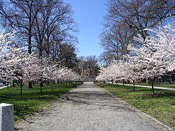
The Princeton Battle Monument park, the visual seen at the western end of Nassau Street
|
|
| Coordinates | 40°20′58.8″N 74°39′35.1″W / 40.349667°N 74.659750°WCoordinates: 40°20′58.8″N 74°39′35.1″W / 40.349667°N 74.659750°W |
|---|---|
| NRHP Reference # | 86003670 |
| Added to NRHP | December 21, 2000 |
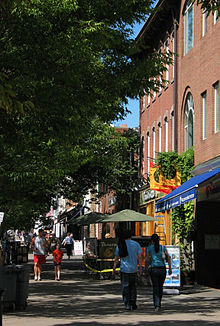
Nassau Street is the main downtown of Princeton, New Jersey famous for its history, high-end stores, restaurants, and college town street life. It is the southernmost portion of Route 27 and has its western end at the intersection with Stockton and Bayard Streets, which form U.S. Route 206. The FitzRandolph Gate of Princeton University opens onto Nassau Street in front of Nassau Hall, at the intersection with Witherspoon Street, which serves as the iconic center of the town of Princeton. Nassau Street is lined with historic landmarks, including monuments, churches, mansions, university buildings, and offices. The street in its entirety is contained with the King's Highway Historic District (New Jersey), the western portion is part of the Princeton Historic District, and the stretch around the intersection with Harrison Street is part of the Jugtown Historic District. The eastern end of Nassau Street is at the intersection with Snowden Lane / Riverside Drive, where the old Princeton Borough ended. The street continues to the east as the Princeton-Kingston Road, leading to the Kingston Mill, Lake Carnegie, Delaware and Raritan Canal, and historic town of Kingston.
Nassau Street serves as a dividing line between Princeton University and the town, with the south side of the street, particularly in its western sections, lined with university buildings, and the northern side lined with shops, restaurants, offices, and apartments. The street is a major shopping destination with stores stretching nearly a mile between Bank Street and Murray Place, with a secondary shopping district around Harrison Street. Dining ranges from landmark college town eatery Hoagie Haven to some of New Jersey's finest restaurants in the blocks immediately north of Nassau along Witherspoon Street and Bayard Lane. Other side streets such as Chambers and South Tulane host rows of stores including the famed Princeton Record Exchange.
...
Wikipedia
