Nash, Newport
Nash
|
|
|---|---|
 Church of St Mary |
|
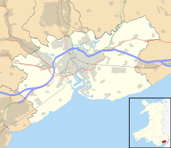
| Nash shown within Newport | |
| Population | 281 (2001 census) |
| Principal area | |
| Ceremonial county | |
| Country | Wales |
| Sovereign state | United Kingdom |
| Post town | NEWPORT |
| Postcode district | NP18 2 |
| Dialling code | 01633 Maindee exchange |
| Police | Gwent |
| Fire | South Wales |
| Ambulance | Welsh |
| EU Parliament | Wales |
| UK Parliament | |
Nash (Welsh: Trefonnen) is a village and community parish to the south of the city of Newport, South Wales, in the Lliswerry ward.
The name is thought to originate from a contraction of "An Ash" (tree), meaning literally `place of the ash tree(s)'. This is supported by its appearance in deeds as "De Fraxino" (fraxinus was the Latin name for the ash tree).
The Welsh name is Trefonnen, given in older sources as Tre'r onnen, also meaning Town (tref) of the Ash (onnen).
Nash and nearby Goldcliff, as Nash and Goldcliffe, are two of the few villages to appear on the Cambriae Typus map of 1573.
Nash lies about 1 mile (1.6 km) to the south of the built-up area of the city of Newport, on the Caldicot Level, a large area of land reclaimed from the sea and crossed by drainage channels and reens. In addition to the village itself, the parish contains Uskmouth power station and part of the Newport Wetlands nature reserve, including its Visitors Centre which was opened in 2008.
The City of Newport campus of Coleg Gwent (commonly referred to as 'Nash College') is actually in the neighbouring parish of Lliswerry.
Together with the neighbouring parishes of Goldcliff and Whitson, Nash is one of the "Three Parishes" which have long been treated as a unit – geographical, socially, economically and ecclesiastically.
The parish is bounded to the south by the sea (Bristol Channel) to the east by the lower reaches of the River Usk and to the north by Lliswerry and the Llanwern Steelworks site. To the west lie Goldcliff and Whitson.
...
Wikipedia

