Nascentes do Rio Taquari State Park
| Nascentes do Rio Taquari State Park | |
|---|---|
| Parque Estadual das Nascentes do Taquari | |
|
IUCN category II (national park)
|
|

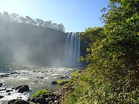
Beleza de Deus waterfall
|
|
| Nearest city | Alcinópolis, Mato Grosso do Sul |
| Coordinates | 18°09′34″S 53°24′40″W / 18.159444°S 53.411105°WCoordinates: 18°09′34″S 53°24′40″W / 18.159444°S 53.411105°W |
| Area | 30,619 hectares (75,660 acres) |
| Designation | State park |
| Created | 9 October 1999 |
| Administrator | Superintendência de Meio Ambiente e Recursos Hídricos |
The Nascentes do Rio Taquari State Park (Portuguese: Parque Estadual das Nascentes do Taquari) is a state park in the state of Mato Grosso do Sul, Brazil. It protects the headwaters of the Taquari River in an area in the transition between the cerrado and pantanal biomes.
The Nascentes do Rio Taquari State Park is divided between the municipalities of Alcinópolis (82.7%) and Costa Rica (17.3%) in Mato Grosso do Sul. It has an area of 30,619 hectares (75,660 acres). The buffer zone covers 89,744.73 hectares (221,764.1 acres). The park contains parts of the Paraguay and Paraná river basins, and is near the watershed of the Araguaia River. It is between the chapadão and the pré-pantanal regions on the border between Mato Grosso do Sul, Mato Grosso and Goiás, and protects the sources of the Taquari River, considered the most degraded river in the pantanal basin of Mato Grosso do Sul.
The park contains six large canyons formed over millions of years in the Chapadão de Baús on the western edge of the Brazilian central plateau. The park has archaeological sites that date back 11,000 years, with traces in caves of ancient rock paintings and petroglyphs. The park has great scenic beauty, and high potential for ecotourism, environmental education and research. The management plan, published in June 2009, defined zones of usage for the park. About 50% is defined as having minimal human intervention, with restricted visitation.
The Nascentes do Rio Taquari State Park is in the Pantanal Biosphere Reserve, which also includes the Pantanal, Chapada dos Guimarães, Emas and Serra da Bodoquena national parks, and the Serra de Santa Bárbara and Pantanal de Rio Negro state parks. It protects an important ecological corridor between the cerrado and the pantanal. Vegetation is in the cerrado biome, and includes seasonal forests and cerradão. Conflicting activities include plowing with intensive use of agrochemicals, mining, roads, transmission lines and homes in the park.
...
Wikipedia

