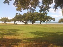
Napili-Honokowai, Hawaii
| Napili-Honokowai, Hawaii | |
|---|---|
| Census-designated place | |

Honokowai Beach Park
|
|
 Location in Maui County and the state of Hawaii |
|
| Coordinates: 20°58′1″N 156°40′14″W / 20.96694°N 156.67056°WCoordinates: 20°58′1″N 156°40′14″W / 20.96694°N 156.67056°W | |
| Country | United States |
| State | Hawaii |
| County | Maui |
| Area | |
| • Total | 4.3 sq mi (11.1 km2) |
| • Land | 2.6 sq mi (6.8 km2) |
| • Water | 1.7 sq mi (4.3 km2) |
| Population (2010) | |
| • Total | 7,261 |
| • Density | 1,700/sq mi (650/km2) |
| Time zone | Hawaii-Aleutian (UTC-10) |
| Area code(s) | 808 |
| FIPS code | 15-54100 |
Nāpili-Honokōwai is a census-designated place (CDP) in Maui County, Hawaiʻi, United States. The population was 7,261 at the 2010 census.
Nāpili-Honokōwai is located at 20°58′1″N 156°40′14″W / 20.96694°N 156.67056°W (20.966949, -156.670672).
According to the United States Census Bureau, the CDP has a total area of 4.3 square miles (11.1 km2), of which 2.6 square miles (6.8 km2) is land and 1.7 square miles (4.3 km2), or 38.35%, is water.
The former Kaanapali Airport and its replacement the Kapalua Airport (known as the Kapalua-West Maui Airport) are in the CDP.
As of the census of 2000, there were 6,788 people, 2,629 households, and 1,469 families residing in the CDP. The population density was 1,153.9 people per square mile (445.7/km²). There were 4,681 housing units at an average density of 795.7 per square mile (307.4/km²). The racial makeup of the CDP was 53.62% White, 0.72% African American, 0.43% Native American, 19.12% Asian, 8.09% Pacific Islander, 4.15% from other races, and 13.86% from two or more races. Hispanic or Latino of any race were 10.72% of the population.
...
Wikipedia
