Nantasket Beach, Massachusetts
| Nantasket Beach Reservation | |
| Metropolitan Park System of Greater Boston | |
|
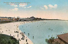
Nantasket Beach circa 1910
|
|
| Country | United States |
|---|---|
| State | Massachusetts |
| County | Plymouth |
| Town | Hull |
| Elevation | 0 ft (0 m) |
| Coordinates | 42°17′30″N 70°52′28″W / 42.29167°N 70.87444°WCoordinates: 42°17′30″N 70°52′28″W / 42.29167°N 70.87444°W |
| Area | 39 acres (16 ha) |
| Established | Unspecified |
| Management | Massachusetts Department of Conservation and Recreation |
| Website: Nantasket Beach Reservation | |
Nantasket Beach is a beach in the town of Hull, Massachusetts. It is part the Nantasket Beach Reservation, administered by the state Department of Conservation and Recreation. The shore has fine, light gray sand and is one of the busiest beaches in Greater Boston. At low tide, there are acres of tide pools.
The name "Nantasket" is derived from Wampanoag and means "at the strait" "low-tide place" or "where tides meet" as Hull is a peninsula. Nantasket was settled not long after Plymouth Colony and before Massachusetts Bay. Roger Conant was in the area after leaving the Plymouth Colony and before going to Cape Ann in 1625. Until Hull was incorporated in 1644, English settlers referred to the whole local region as "Nantasket Peninsula."
In 1825, Paul Warrick established "The Sportsman Hotel" on Nantasket Avenue. Later, more hotels were built and steamboats made three trips a day between Nantasket Beach and Boston in the 1840s. In 1909, an amusement area called Paragon Park was built adjacent to the beach. This was closed in 1985.
...
Wikipedia


