Nantan, Kyoto
|
Nantan 南丹市 |
|||
|---|---|---|---|
| City | |||

Nantan City hall
|
|||
|
|||
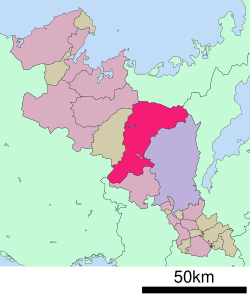
 Location of Nantan in Kyoto Prefecture |
|||
| Location in Japan | |||
| Coordinates: 35°6′N 135°28′E / 35.100°N 135.467°ECoordinates: 35°6′N 135°28′E / 35.100°N 135.467°E | |||
| Country | Japan | ||
| Region | Kansai | ||
| Prefecture | Kyoto Prefecture | ||
| Government | |||
| • Mayor | Toshinori Sasaki (since April 2006) | ||
| Area | |||
| • Total | 616.31 km2 (237.96 sq mi) | ||
| Population (August 1, 2016) | |||
| • Total | 32,771 | ||
| • Density | 53/km2 (140/sq mi) | ||
| Symbols | |||
| • Tree | Fagus crenata | ||
| • Flower | Cherry blossom | ||
| • Bird | Blue-and-white flycatcher | ||
| Time zone | Japan Standard Time (UTC+9) | ||
| Website | www |
||
Nantan (南丹市 Nantan-shi?) is a city located in Kyoto Prefecture, Japan.
As of August 1, 2016, the city has an estimated population of 32,771 and a population density of 53 persons per km². The total area is 616.31 km².
The modern city of Nantan was established on January 1, 2006, from the merger of the towns of Hiyoshi, Sonobe and Yagi (all from Funai District), and the town of Miyama (from Kitakuwada District). The name of Nantan stands for "southern Tamba".
Sights include the Rurikei Prefectural Natural Park and Miyama Kayabuki no sato "Thatched farmhouses village".
...
Wikipedia


