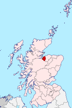
Nairn (local government district, Highland region)
| County of Nairn | |
|---|---|
| Historic county | |
 |
|
| Country | Scotland |
| County town | Nairn |
| Area | |
| • Total | 200 sq mi (518 km2) |
| Ranked 31st of 34 | |
| Chapman code | NAI |
The County of Nairn (also called Nairnshire) is a historic county, registration county and lieutenancy area of Scotland. The county was used for local administration until the county council, based at the county town of Nairn, was abolished in 1975 under the Local Government (Scotland) Act 1973, the area becoming one of the eight districts of the two-tier Highland region. This arrangement ended in 1996 when the Highland council area was made an unitary authority.
The county borders Inverness-shire to the west and south, Moray to the east, and has a coastline along the Moray Firth to its north.
The county (Scottish Gaelic: Siorrachd Inbhir Narann), was described in 1846 as:
"about twenty-two miles in length and fifteen miles (35x24 km) in breadth; comprising an area of 200 square miles (520 km2), or 128,000 acres; 2338 houses, of which 2235 are inhabited; and containing a population of 9217."
Nairn can be seen from several distant points such as Ben Rinnes, a peak that is a common point of distant view to such places as Inverness-shire and Longman Hill in Banffshire. To the north, Nairn is bounded by the Moray Firth.
Nairn (Scottish Gaelic: Inbhir Narann) is a land registration county.
...
Wikipedia
