Nagykálló
| Nagykálló | |
|---|---|

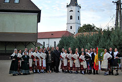
The inhabitants in traditional customes with the church tower in the background
|
|
| Country |
|
| County | Szabolcs-Szatmár-Bereg |
| Area | |
| • Total | 68.55 km2 (26.47 sq mi) |
| Population (2005) | |
| • Total | 10,483 |
| • Density | 157.75/km2 (408.6/sq mi) |
| Time zone | CET (UTC+1) |
| • Summer (DST) | CEST (UTC+2) |
| Postal code | 4320 |
| Area code(s) | 42 |
Nagykálló is a small town in Szabolcs-Szatmár-Bereg county, in the Northern Great Plain region of eastern Hungary. Before World War II it belonged to Szabolcs county.
14 km (9 mi) from county seat Nyíregyháza.
Nagykálló was already an oppidum (market town) in the 14th century. Its name probably comes from the old word kálló meaning "gathering place". Nagy means "large"; this prefix was used to differentiate between Nagykálló and the nearby Kiskálló ("small Kálló"), which later became a part of Nagykálló.
In 1315 King Charles Robert granted the town rights to hold a market, later the county councils were held here, thus the town became the centre of the region. After the Ottomans burnt the town in 1556, the citizens built a stone castle for defence. In 1603 István Bocskai settled Hajdúk in the town. After his death they moved to Hajdúböszörmény, but Nagykálló remained an important industrial centre. It was the property of the Kállay de Nagy-Kálló family.
In 1630 George II Rákóczi occupied the town and issued the Proclamation of Independence here. Francis II Rákóczi attacked the castle on July 29, 1703 (first battle of the war for freedom) and occupied it the following day. In 1704 he ordered the castle to be destroyed (it was destroyed only later, in 1709). In 1747 the town became the county seat of Szabolcs county, but this role was taken over by Nyíregyháza in 1867. Nagykálló was granted town status again in 1989.
Coordinates: 47°53′N 21°51′E / 47.883°N 21.850°E
...
Wikipedia
