Nagareyama
|
Nagareyama 流山市 |
|||
|---|---|---|---|
| City | |||

Nagareyama City Hall
|
|||
|
|||
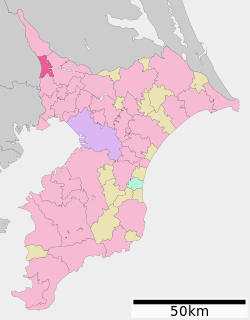
 Location of Nagareyama in Chiba Prefecture |
|||
| Coordinates: 35°51′22.7″N 139°54′10.3″E / 35.856306°N 139.902861°ECoordinates: 35°51′22.7″N 139°54′10.3″E / 35.856306°N 139.902861°E | |||
| Country | Japan | ||
| Region | Kantō | ||
| Prefecture | Chiba Prefecture | ||
| Government | |||
| • Mayor | Yoshiharu Izaki (since May 2003) | ||
| Area | |||
| • Total | 35.28 km2 (13.62 sq mi) | ||
| Population (April 2012) | |||
| • Total | 166,493 | ||
| • Density | 4,720/km2 (12,200/sq mi) | ||
| Time zone | Japan Standard Time (UTC+9) | ||
| -Tree | Japanese Box | ||
| - Flower | Rhododendron | ||
| Phone number | 04-7158-1111 | ||
| Address | 1-1-1, Heiwadai, Nagareyama-shi, Chiba-ken 270-0192 | ||
| Website | www |
||
Nagareyama (流山市 Nagareyama-shi?) is a city located in northern Chiba Prefecture, Japan.
As of April 2012, the city has an estimated population of 166,493 and a population density of 4,720 persons per km². The total area is 35.28 km2 (13.62 sq mi).
Nagareyama is located in the far northwestern corner of Chiba Prefecture, bordered by the Edogawa River to the west.
During the Edo period, Nagareyama was a river port on the Edogawa River. After the Meiji Restoration, Nagareyama Town was created in Inba District, Chiba Prefecture on April 1, 1889. On January 1, 1952, it merged with neighboring Edogawa Town to form a new Nagareyama Town. Nagareyama became a city on January 1, 1967.
Nagareyama is a regional commercial center and a bedroom community for nearby Chiba and Tokyo. The city is also noted for its production of mirin, a sweetened sake used for cooking.
Nagareyama is twinned with:
...
Wikipedia


