NY 353
| New York State Route 353 | ||||
|---|---|---|---|---|

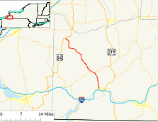
Map of Cattaraugus County and vicinity with NY 353 highlighted in red
|
||||
| Route information | ||||
| Maintained by NYSDOT and the city of Salamanca | ||||
| Length: | 23.97 mi (38.58 km) | |||
| Existed: | c. 1933 – present | |||
| Major junctions | ||||
| South end: |
|
|||
| North end: |
|
|||
| Location | ||||
| Counties: | Cattaraugus | |||
| Highway system | ||||
|
||||
New York State Route 353 (NY 353) is a north–south state highway located within Cattaraugus County, New York, in the United States. It extends for 23.97 miles (38.58 km) from an intersection with NY 417 in the city of Salamanca to a junction with U.S. Route 62 (US 62) in the hamlet of Dayton. In between, the route traverses isolated and undeveloped areas of the county, save for the villages of Little Valley and Cattaraugus. In the latter, NY 353 intersects and briefly overlaps with NY 242.
NY 353 was assigned c. 1933 to a north–south highway connecting Dayton to nearby Perrysburg. At the time, modern NY 353 was part of NY 18, which extended from the Pennsylvania state line to Rochester via Buffalo. NY 18 was cut back to its current western terminus north of Buffalo c. 1962, at which time NY 353 was extended southeastward to Salamanca over NY 18's former routing. The original Dayton–Perryburg segment of NY 353 was transferred to Cattaraugus County in 1980 and is now part of County Route 58 (CR 58).
...
Wikipedia

