NH 30A
| National Highway 10 | ||||
|---|---|---|---|---|

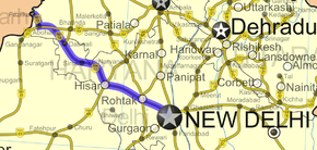
Road map of India with National Highway 10 highlighted in solid blue color
|
||||
| Route information | ||||
| Length: | −1 km (0 mi) | |||
| Major junctions | ||||
| East end: | Delhi | |||
| West end: | Fazilka | |||
| Location | ||||
| States: |
Delhi: 18 km Haryana: 313 km Punjab: 72 km |
|||
| Primary destinations: |
Delhi - Rohtak - Hisar - Sirsa - Fazilka | |||
| Highway system | ||||
|
||||
National Highway 10 was a National Highway, length 403 km (250 mi), in northern India that originates at Delhi and ends at the town of Fazilka in Punjab near the Indo-Pak Border. It is now part of the renumbered National Highway 9.
As of 2016 June, a special purpose vehicle, Rohtak-Hissar Tollway Pvt Ltd, completed the widening of the stretch from Hissar to Rohtak to four lanes (two lanes in each direction with wide paved shoulders and a tree-lined median in the middle). The concession period for the project, including the construction period, is 22 years.
The National Highways Authority of India's National Highways Development Project NHAI NHDP Phase-3 project has acquired additional 591.84 hectares of land for road widening and building:
The project in Build–operate–transfer (BOT) toll road mode is on a design, built, finance, operate and transfer (DBFOT) pattern, having a concession period of 24 years including a 2.5 years construction period. The project was started in 2015 and is progressing at a good pace. The project is expected to be completed on time. It also covers the following:
Safety improvements undertaken by NHAI and PWD since 2012 have resulted in a decline in road fatalities on NH10. Scheduled improvements include rumble strips, additional signage, and reflective markers.
...
Wikipedia

