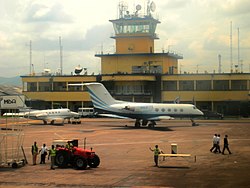
N'djili Airport
|
N'djili Airport Aéroport de N'djili |
|||||||||||
|---|---|---|---|---|---|---|---|---|---|---|---|

Air Traffic Control Tower (ATCT) at Kinshasa International Airport
|
|||||||||||
| Summary | |||||||||||
| Airport type | Public | ||||||||||
| Location | Kinshasa, Democratic Republic of the Congo | ||||||||||
| Hub for | Congo Airways | ||||||||||
| Elevation AMSL | 1,027 ft / 313 m | ||||||||||
| Coordinates | 04°23′08.7″S 15°26′40.45″E / 4.385750°S 15.4445694°ECoordinates: 04°23′08.7″S 15°26′40.45″E / 4.385750°S 15.4445694°E | ||||||||||
| Map | |||||||||||
| Location of Airport in Democratic Republic of the Congo | |||||||||||
| Runways | |||||||||||
|
|||||||||||
| Statistics (2014) | |||||||||||
|
|||||||||||
| Passengers | 773,338 |
|---|
N'djili Airport (IATA: FIH, ICAO: FZAA), also known as N'Djili International Airport and Kinshasa International Airport, serves the city of Kinshasa and is the largest of the four international airports in the Democratic Republic of the Congo (DRC). It is named after the nearby Ndjili River.
In 1998, N'Djili airport was the site of one of the decisive battles of the Second Congo War. Rebel forces advancing on Kinshasa infiltrated the airport perimeter but were repulsed by Zimbabwean troops and aircraft arriving to support the government of Laurent Kabila.
The airport has barely been maintained or upgraded and is still using the infrastructure built by the Belgians during the colonial era. In June 2015 a new international terminal was opened which can service 1 million passengers per year. Some computerized upgrades to the arrivals terminal have been implemented in recent years although corruption remains present.
Terminal building at Kinshasa International Airport
N'Djili airport at night
An old plane resting on the airfield
![]() This article incorporates public domain material from the Air Force Historical Research Agency website http://www.afhra.af.mil/.
This article incorporates public domain material from the Air Force Historical Research Agency website http://www.afhra.af.mil/.
...
Wikipedia

