Myōkō, Niigata
|
Myōkō 妙高市 |
|||
|---|---|---|---|
| City | |||

Myōkō City Hall
|
|||
|
|||
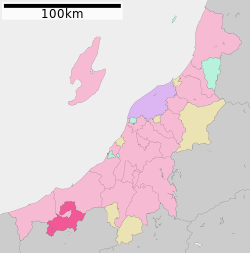
 Location of Myōkō in Niigata |
|||
| Coordinates: 37°1′30.7″N 138°15′12.7″E / 37.025194°N 138.253528°ECoordinates: 37°1′30.7″N 138°15′12.7″E / 37.025194°N 138.253528°E | |||
| Country | Japan | ||
| Region | Chūbu (Kōshin'etsu) (Hokuriku) | ||
| Prefecture | NIigata | ||
| Area | |||
| • Total | 445.63 km2 (172.06 sq mi) | ||
| Population (June 2016) | |||
| • Total | 32,829 | ||
| • Density | 73.7/km2 (191/sq mi) | ||
| Time zone | Japan Standard Time (UTC+9) | ||
| Symbols | |||
| • Tree | Fagus crenata | ||
| • Flower | Glaucidium palmatum | ||
| • Bird | Blue-and-white flycatcher | ||
| Phone number | 0255-72-5111 | ||
| Address | 5-1 Sakaemachi, Myoko-shi, Niigata-ken 944-8686 | ||
| Website | www |
||
Myōkō (妙高市 Myōkō-shi?) is a city located in south-central Niigata Prefecture, in the Hokuriku region of Japan. As of 1 June 2016[update], the city had an estimated population of 32,829 and a population density of 73.7 persons per km². Its total area was 445.63 square kilometres (172.06 sq mi).
Myōkō is located in an inland region of north-central Niigata Prefecture, on the border of Nagano Prefecture. It lies in mountain surroundings near the historical entrance to the Echigo Plains. The city is surrounded by five mountains. Madarao, Myōkō, Kurohime, Togakushi and Iizuna are collectively known as the Five Peaks of Northern Shinano (Hokushingogaku). They make up the border of Nagano and Niigata Prefectures. As the city name implies, Mount Myōkō (2,454 metres (8,051 feet) ) is in the city, much of which is within the borders of the Myōkō-Togakushi Renzan National Park.
The area of present-day Myōkō was part of ancient Echigo Province. The modern city of Myōkō was established on April 1, 2005, from the merger of the city of Arai and the town of Myōkōkōgen, and the village of Myōkō (both from Nakakubiki District)
...
Wikipedia


