Muttontown, New York
| Muttontown, New York | |
|---|---|
| Village | |
| Incorporated Village of Muttontown | |
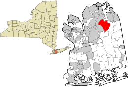
 Location in Nassau County and the state of New York. |
|
| Location within the state of New York | |
| Coordinates: 40°49′20″N 73°31′37″W / 40.82222°N 73.52694°WCoordinates: 40°49′20″N 73°31′37″W / 40.82222°N 73.52694°W | |
| Country | United States |
| State | New York |
| County | Nassau |
| Government | |
| • Mayor | Julianne Wesley Beckerman |
| Area | |
| • Total | 6.1 sq mi (15.8 km2) |
| • Land | 6.1 sq mi (15.8 km2) |
| • Water | 0.0 sq mi (0.0 km2) |
| Elevation | 285 ft (87 m) |
| Population (2010) | |
| • Total | 3,497 |
| Time zone | Eastern (EST) (UTC-5) |
| • Summer (DST) | EDT (UTC-4) |
| Area code(s) | 516 |
| FIPS code | 36-49330 |
| GNIS feature ID | 0958224 |
| Website | www |
The Incorporated Village of Muttontown is a village located within the Town of Oyster Bay in Nassau County, New York, United States. The population was 3,497 at the 2010 census. Muttontown was ranked one of the wealthiest towns in America by BusinessWeek. The village and surrounding areas, which make up the "Gold Coast" of Long Island, have historically been home to some of the most affluent families in New York. The name of the village stems from its former use as pasturage for sheep.
During colonial times the area was used to raise sheep for wool and meat. The village was incorporated in 1931. Zog of Albania bought the town's Knollwood estate in 1951, but sold it in 1955. The Benjamin Moore Estate was listed on the National Register of Historic Places in 1979.
Muttontown is served by the Locust Valley Central School District, the Jericho Union Free School District and the Syosset Central School District since Muttontown doesn't have its own school district.
Muttontown is located at 40°49′20″N 73°31′37″W / 40.82222°N 73.52694°W (40.822251, -73.527081).
...
Wikipedia

