Murphy, North Carolina
| Murphy, North Carolina | |
|---|---|
| Town | |

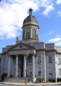
Cherokee County Courthouse
|
|
 Location of Murphy, North Carolina |
|
| Coordinates: 35°5′23″N 84°1′48″W / 35.08972°N 84.03000°WCoordinates: 35°5′23″N 84°1′48″W / 35.08972°N 84.03000°W | |
| Country | United States |
| State | North Carolina |
| County | Cherokee |
| Area | |
| • Total | 2.6 sq mi (6.8 km2) |
| • Land | 2.4 sq mi (6.2 km2) |
| • Water | 0.2 sq mi (0.6 km2) |
| Elevation | 1,604 ft (489 m) |
| Population (2014) | |
| • Total | 2,420 |
| • Density | 679/sq mi (262.1/km2) |
| Time zone | Eastern (EST) (UTC-5) |
| • Summer (DST) | EDT (UTC-4) |
| ZIP code | 28906 |
| Area code(s) | 828 |
| FIPS code | 37-45660 |
| GNIS feature ID | 1013848 |
| Website | www |
Murphy is a town in and the county seat of Cherokee County, North Carolina, United States. It is situated at the confluence of the Hiwassee and Valley rivers. It is the westernmost county seat in the state of North Carolina, approximately 360 miles (580 km) from the state capital in Raleigh. The population of Murphy was 2,420 at the 2014 census.
Murphy was named for North Carolina politician Archibald Murphey.
The site of Murphy, along the Hiwassee River, was known to the Cherokee as Tlanusi-yi (the Leech Place), because of a legend about a giant leech named Tlanusi that lived in the river there.
The Trading Path (later called the "Unicoi Turnpike") passed by the future site of Murphy, connecting the Cherokee lands east of the mountains with the "Overhill Towns" of Tennessee.
The town was first called by the name of "Huntington" in 1835 when the first post office, operated by Col. H.R.S. Hunter was established.
In 1836, during the Cherokee removal known as the Trail of Tears, the United States army built Fort Butler in what is today Murphy. Fort Butler acted as the main collection point for Cherokee east of the mountains. From Fort Butler the Cherokee were taken over the mountains on the Unicoi Turnpike to the main internment camps at Fort Cass (today Charleston, Tennessee). Today the Unicoi Turnpike is known as the Joe Brown Highway. The Cherokee County Historical Museum located in Murphy provides information about the Trail of Tears.
Cherokee County was formed in 1839 from a portion of Macon County, but Murphy wasn't incorporated as the county seat until 1851.
...
Wikipedia
