Muriaux
| Muriaux | ||
|---|---|---|

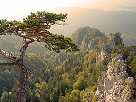
Rocky peaks near the ruins of Spiegelberg by Muriaux village
|
||
|
||
| Coordinates: 47°15′N 06°59′E / 47.250°N 6.983°ECoordinates: 47°15′N 06°59′E / 47.250°N 6.983°E | ||
| Country | Switzerland | |
| Canton | Jura | |
| District | Franches-Montagnes | |
| Government | ||
| • Mayor | Maire | |
| Area | ||
| • Total | 16.89 km2 (6.52 sq mi) | |
| Elevation | 947 m (3,107 ft) | |
| Population (Dec 2015) | ||
| • Total | 504 | |
| • Density | 30/km2 (77/sq mi) | |
| Postal code | 2338 | |
| SFOS number | 6753 | |
| Surrounded by | Le Noirmont, Goumois, Les Pommerats, Saignelégier, La Chaux-des-Breuleux, Les Breuleux, Le Peuchapatte, Villeret(BE), Saint-Imier(BE) | |
| Website |
www SFSO statistics |
|
Muriaux is a municipality in the district of Franches-Montagnes in the canton of Jura in Switzerland. On 1 January 2009, the formerly independent municipality of Le Peuchapatte merged into the municipality of Muriaux.
Muriaux is first mentioned in 1301 as Murival. The municipality was formerly known by its German name Spiegelberg, however, that name is no longer used.
Muriaux has an area of 16.89 km2 (6.52 sq mi). Of this area, 10.22 km2 (3.95 sq mi) or 60.5% is used for agricultural purposes, while 6.1 km2 (2.4 sq mi) or 36.1% is forested. Of the rest of the land, 0.54 km2 (0.21 sq mi) or 3.2% is settled (buildings or roads) and 0.03 km2 (7.4 acres) or 0.2% is unproductive land.
Of the built up area, housing and buildings made up 1.5% and transportation infrastructure made up 1.6%. Out of the forested land, 31.4% of the total land area is heavily forested and 4.7% is covered with orchards or small clusters of trees. Of the agricultural land, 5.7% is used for growing crops and 33.9% is pastures and 20.8% is used for alpine pastures.
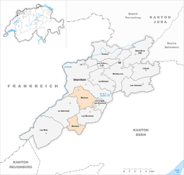
The widely scattered settlements of municipality are located in the Franches-Montagnes district. It consists of the village of Muriaux west of the Saignelégier-Le Noirmont road, the hamlets of Les Emibois, Les Chenevières, Le Roselet, the exclave of Le Cerneux-Veusil between the municipalities of Saint-Imier and Les Breuleux and the former municipality of Le Peuchapatte.
The municipalities of Le Bémont, Les Bois, Les Breuleux, La Chaux-des-Breuleux, Les Enfers, Les Genevez, Lajoux, Montfaucon, Muriaux, Le Noirmont, Saignelégier, Saint-Brais and Soubey are considering a merger on at a date in the future into the new municipality of Franches-Montagnes.
...
Wikipedia


