Muree
|
Murree مری |
||||||||
|---|---|---|---|---|---|---|---|---|
j
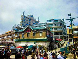
Right to Left from above to bottom. Patriatta Cable Car, View of Murree, colonial era church, house's in old Murree, view of valley and Mall Road.
|
||||||||
| Nickname(s): The Depot (British India), The White City | ||||||||
| Location within Pakistan | ||||||||
| Coordinates: 33°54′15″N 73°23′25″E / 33.90417°N 73.39028°ECoordinates: 33°54′15″N 73°23′25″E / 33.90417°N 73.39028°E | ||||||||
| Country |
|
|||||||
| Province | Punjab | |||||||
| District | Rawalpindi | |||||||
| Tehsil | Murree | |||||||
| Government | ||||||||
| • MNA (NA-50) | Shahid Khaqan Abbasi (PML-N) | |||||||
| Elevation | 2,291.2 m (7,517.1 ft) | |||||||
| Population | ||||||||
| • Total | 25,247 | |||||||
| Time zone | PST (UTC+5) | |||||||
| Number of Union councils | 1 | |||||||
| Murree | ||||||||||||||||||||||||||||||||||||||||||||||||||||||||||||
|---|---|---|---|---|---|---|---|---|---|---|---|---|---|---|---|---|---|---|---|---|---|---|---|---|---|---|---|---|---|---|---|---|---|---|---|---|---|---|---|---|---|---|---|---|---|---|---|---|---|---|---|---|---|---|---|---|---|---|---|---|
| Climate chart () | ||||||||||||||||||||||||||||||||||||||||||||||||||||||||||||
|
||||||||||||||||||||||||||||||||||||||||||||||||||||||||||||
|
||||||||||||||||||||||||||||||||||||||||||||||||||||||||||||
| J | F | M | A | M | J | J | A | S | O | N | D |
|
127
7
0
|
145
8
1
|
177
12
4
|
133
17
9
|
92
22
13
|
130
25
16
|
340
22
16
|
326
21
15
|
147
21
13
|
70
19
10
|
33
15
6
|
70
10
2
|
| Average max. and min. temperatures in °C | |||||||||||
| Precipitation totals in mm | |||||||||||
| Source: World Weather Information Service | |||||||||||
| Imperial conversion | |||||||||||
|---|---|---|---|---|---|---|---|---|---|---|---|
| J | F | M | A | M | J | J | A | S | O | N | D |
|
5
45
32
|
5.7
46
33
|
7
53
40
|
5.2
63
48
|
3.6
71
55
|
5.1
...
| ||||||


