Murakami, Niigata
|
Murakami 村上市 |
|||
|---|---|---|---|
| City | |||

Murakami Taisai Festival
|
|||
|
|||
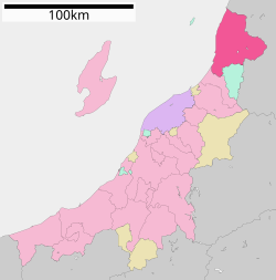
 Location of Murakami in Niigata Prefecture |
|||
| Coordinates: 38°13′26.4″N 139°28′48″E / 38.224000°N 139.48000°ECoordinates: 38°13′26.4″N 139°28′48″E / 38.224000°N 139.48000°E | |||
| Country | Japan | ||
| Region | Chūbu (Kōshin'etsu) (Hokuriku) | ||
| Prefecture | NIigata | ||
| Area | |||
| • Total | 1,174.26 km2 (453.38 sq mi) | ||
| Population (June 2016) | |||
| • Total | 61,747 | ||
| • Density | 52.6/km2 (136/sq mi) | ||
| Time zone | Japan Standard Time (UTC+9) | ||
| Symbols | |||
| • Tree | Fagus crenata | ||
| • Flower | Rosa rugosa | ||
| • Bird | Spizaetus nipalensis | ||
| Phone number | 0254-53-2111 | ||
| Address | 1-1, Sannochō, Murakami-shi, Niigata-ken 958-8501 | ||
| Website | www |
||
Murakami (村上市 Murakami-shi?) is a city located in far northern Niigata Prefecture, in the Hokuriku region of Japan. As of 1 June 2016[update], the city had an estimated population of 61,747 and a population density of 52.6 persons per km². Its total area was 1,174.26 square kilometres (453.38 sq mi).
Niigata is located on the Sea of Japan coast of far northern Niigata Prefecture, bordered by Yamagata Prefecture to the north and east.
The area of present-day Murakai was part of ancient Echigo Province. Murakami developed as a port and a castle town for the Murakami Domain under the Tokugawa shogunate in the Edo period. Even today, the downtown area shows the influence of its past existence as a residence of samurai and merchants. Following the Meiji restoration, the area became part of Iwafune District, Niigata, and the town of Murakami was established with the establishment of the municipalities system on April 1, 1889. Murakami was raised to city status on March 31, 1954. OnApril 1, 2008, the towns of Arakawa and Sanpoku and the villages of Asahi and Kamihayashi (all from Iwafune District) were merged into Murakami.
...
Wikipedia


