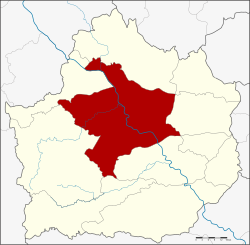
Mueang Kamphaeng Phet District
|
Mueang Kamphaeng Phet เมืองกำแพงเพชร |
|
|---|---|
| Amphoe | |
 Amphoe location in Kamphaeng Phet Province |
|
| Coordinates: 16°29′0″N 99°31′12″E / 16.48333°N 99.52000°ECoordinates: 16°29′0″N 99°31′12″E / 16.48333°N 99.52000°E | |
| Country |
|
| Province | Kamphaeng Phet |
| Seat | Nai Mueang |
| Area | |
| • Total | 1,962.0 km2 (757.5 sq mi) |
| Population (2015) | |
| • Total | 213,228 |
| • Density | 108.1/km2 (280/sq mi) |
| Time zone | THA (UTC+7) |
| Postal code | 62000 |
| Geocode | 6201 |
Mueang Kamphaeng Phet (Thai: เมืองกำแพงเพชร) is the capital district (Amphoe Mueang) of Kamphaeng Phet Province, central Thailand.
Neighboring districts are (from the northwest clockwise) Kosamphi Nakhon, Phran Kratai, Sai Ngam, Khlong Khlung, Khlong Lan of Kamphaeng Phet Province and Wang Chao of Tak Province.
In 1917 the district was renamed from Mueang to Mueang Kamphaeng Phet.
The district Mueang Kamphaeng Phet is subdivided into 16 subdistricts (Tambon), which are further subdivided into 220 administrative villages (Muban).
Missing numbers are the tambon which now form Kosamphi Nakhon district.
There are 2 towns (Thesaban Mueang) in the district:
There are 5 subdistrict municipalities (Thesaban Tambon) in the district:
There are 12 subdistrict administrative organizations (SAO) in the district:
...
Wikipedia
