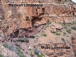
Muav Limestone
| Muav Limestone Stratigraphic range: Middle Cambrian |
|
|---|---|

representative sequence of Redwall, Temple Butte, and Muav Limestone, in Grand Canyon
|
|
| Type | Geological formation |
| Unit of | Tonto Group |
| Underlies | Redwall Limestone (Mississippian). Locally underlies Temple Butte Limestone (Devonian) that fills narrow paleovalleys cut into the unconformity separating the Redwall Limestone from Muav Limestone. |
| Overlies | Bright Angel Shale |
| Thickness | 650 feet (200 m), at maximum |
| Lithology | |
| Primary | limestone and dolomite |
| Other | calcareous mudstone |
| Location | |
| Region | Northern Arizona (Grand Canyon), central Arizona, southeast California, southern Nevada, and southeast Utah |
| Country | United States of America |
| Type section | |
| Named for | Muav Canyon, north side of Colorado River |
| Named by | Noble (1914) |
The Cambrian Muav Limestone is the upper geologic unit of the 3-member Tonto Group. It is about 650 feet (198 m) thick at its maximum. It is a resistant cliff-forming unit. The Muav consists of dark to light-gray, brown, and orange red limestone with dolomite and calcareous mudstone. The Muav is overlain in some areas by the Devonian Temple Butte Limestone, but the major unit above are the vertical cliffs of Mississippian Redwall Limestone. The Muav is located in the lower elevations of the Grand Canyon, Arizona.
The Muav is in-part younger than, and in-part grades into, the Bright Angel Shale which is less erosion resistant and is categorized as a slope-forming unit. The Muav is about 350 feet thick in the east and reaches about 600 feet thick in the western part of its exposure area in the Grand Canyon. The two units lie above the erosion-resistant cliff-forming Tapeats Sandstone. In the eastern canyon, the Tapeats creates the horizontal Tonto Platform. In west Grand Canyon, the north-south Toroweap Fault is the west perimeter of the Tonto Platform, and west Grand Canyon is dominated by the erosion resistant unit of the Esplanade Sandstone. The Tonto Trail is a mostly horizontal trail on the south side of Granite Gorge, on the platform.
The Tonto Group units were deposited on an ancient erosion surface (angular unconformity) on the Vishnu Basement Rocks. The Vishnu sequence has a dip of about 45 degrees. As this unconformity represents about 1,000 million years (1.0 billion years) of non–deposition, tectonic activity and erosion on the Vishnu Basement Rocks is called the Great Unconformity.
...
Wikipedia
