Mt. Werner
| Mount Werner | |
|---|---|

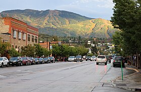
The mountain viewed from Lincoln Avenue in Steamboat Springs
|
|
| Highest point | |
| Elevation | 10,570 ft (3,220 m) |
| Isolation | 7.10 mi (11.43 km) |
| Coordinates | 40°27′22″N 106°44′25″W / 40.4560895°N 106.7403244°WCoordinates: 40°27′22″N 106°44′25″W / 40.4560895°N 106.7403244°W |
| Geography | |
|
|
|
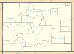
| Location | Routt County, Colorado, U.S. |
| Parent range | Park Range |
| Topo map |
USGS 7.5' topographic map Mount Werner, Colorado |
Mount Werner is a mountain summit in the Park Range of the Rocky Mountains of North America. The 10,570-foot (3,222 m) peak is located in Routt National Forest, 4.6 miles (7.4 km) east-southeast (bearing 107°) of the City of Steamboat Springs in Routt County, Colorado, United States. The mountain was renamed in 1964 in honor of skier Buddy Werner.
Mount Werner is 150 miles (240 km) northwest of Denver. The mountain reaches a height of 10,570 feet (3,220 m) above sea level and has a base elevation of 6,900 feet (2,100 m), for a vertical rise of 3,670 feet (1,120 m). It has five peaks (from lowest to highest), Christie Peak, Thunderhead Peak, Sunshine Peak, Storm Peak, and Mount Werner.
Formerly known as Storm Mountain, it was renamed in 1965 in honor of Buddy Werner, an Olympian from Steamboat Springs who was killed in an avalanche in Switzerland in April 1964.
Mount Werner stands within the watershed of the Yampa River, which drains into the Green River, the Colorado River, and thence into the Gulf of California in Mexico.
The Steamboat Ski Resort operates on 2,965 acres (12.00 km2) of the mountain. It is serviced by the Silver Bullet gondola lift and several chairlifts. It regularly receives some of the highest levels of snow in Colorado. The most recent ten year snowfall average was 334 inches (8.5 m) per year. Much of the mountain and the resort are contained within the Routt National Forest.
...
Wikipedia

